

La Florida
1584 · Jerónimo de Chaves; published by Abraham Ortelius · University of South Florida Libraries
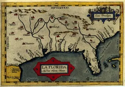
It represents a region much larger than the present-day state of Florida, in the North American southeast.
How to interpret the map
It does not reproduce exclusively Ponce de León's expedition of 1513. The date of the plate is later and its territorial scope is different from today's.
To assess this map, compare its production date with the dates of the voyage you are studying. A territory or place name appearing on the chart does not by itself establish an arrival, landing or occupation. Open the provenance record to check the work’s identification, and consult each voyage’s sources to examine its itinerary.
Provenance and rights
Jerónimo de Chaves; published by Abraham Ortelius. University of South Florida Libraries. Provenance of the reproduction indicated in its link.
Institutional record · Public domain work; consult the conditions of the reproduction
Send comments to the author
Found an error or have information to contribute? Write privately to the author.