

Pinzón's Expedition: Discovery of Brazil and the Amazon
In this entry · 18 sections
- Context
- Stages
- Events of this expedition
- Route data
- Outcome
- Limits of the evidence
- Expedition facts
- Organisation
- Objectives
- Encounters and societies
- Recorded vessels
- People and societies
- Related people
- Related cartography
- Art and memory
- Other expeditions with shared protagonists
- Sources and references
- Further reading and comparison
Expedition · 1499. Vicente Yáñez Pinzón.
Varela dates Vicente Yáñez Pinzón’s agreement at Seville to 6 June 1499 and departure from Sanlúcar to early December. He describes family capital, captains and pilots, and the aim of reaching Cathay and Cipango. That aim is distinguished from the voyage’s results. [B43]
The same study dates the sighting of the Brazilian coast to 24 January 1500 and discusses identification of Cape Consolación. It reconstructs navigation past major river mouths and reconnaissance of the archipelago at the Amazon’s mouth; this does not equate to travelling the entire river. [B43]
The campaign continued via the Orinoco, Trinidad and the Caribbean. Varela reports the loss of two caravels in July without identifying the island where the storm occurred, and dates return to Palos to 30 September 1500. [B43]
Context
Varela describes the Seville agreement of 6 June 1499 and the Pinzón family’s capital contribution to seek a route to Cathay and Cipango. He places departure from Sanlúcar in early December. [B43]
Stages
- Late 1499, Sanlúcar de Barrameda: Departure from Sanlúcar in early December 1499 according to Varela, distinguished from the family’s residence and connections at Palos. [B43]
- January 1500, Coast of present-day Brazil: Varela dates the sighting to 24 January 1500 and discusses identification of the cape. The traditional 26 January is not treated as an agreed date, and no exact landing is fixed. [B43]
- 1500, Northern coast of Brazil: Sailing northwest. [B43]
- 1500, Vicinity of the Amazon mouth: Observation of extensive fresh waters in the ocean. [B43]
- 1500, Caribbean and return: Continuation of the campaign and return to the Peninsula. [B43]
Events of this expedition
Route data
- Four caravels; Varela does not identify the island where the storm that sank two took place.
- First documented Castilian landing on the coast of present-day Brazil, months before Cabral.
- Pinzón described the “fresh sea” at the mouth of the Amazon.
Outcome
News of the Brazilian coast and the Amazon mouth entered European cartography. [B43]
Reconnaissance of the river mouth and estuarine archipelago is distinguished from Orellana’s later Amazon crossing. It is not inferred that Pinzón travelled the river from its source. [B43] [B66]
Limits of the evidence
There is no definitive agreement on the identification of the cape of the first landing. [B43]
The claim that Pinzón traveled the Amazon River from its source is removed: the surviving information corresponds to its mouth and coastal surroundings. [B43]
Expedition facts
| Date | 1499 |
|---|---|
| Leader | Vicente Yáñez Pinzón |
| Departure | Sanlúcar de Barrameda |
| Destination | — |
| Period | 1499–1500 |
Organisation
Varela dates departure from Sanlúcar to early December 1499. He describes four caravels in the campaign and the loss of two in a July 1500 storm, without specifying which island they were then at. [B43] [B43]
Objectives
- To survey coasts lying farther south than the Columbian voyages [B43]
- To seek resources and new navigational possibilities [B43]
Encounters and societies
The study reconstructs travel and trading in inhabited territories and explains the search for cargo to avert the family enterprise’s ruin. This is a historiographical perspective, not testimony from the visited communities. [B43]
Recorded vessels
- Four vessels; two were lost during the campaign, according to historical reconstructions [B43]
People and societies
- Vicente Yáñez Pinzón: Head of the fleet and navigator [B43]
- Crews of the four vessels: Sailors and personnel of the expedition; no full roll is given without cross-checking [B43]
Related people
Related cartography
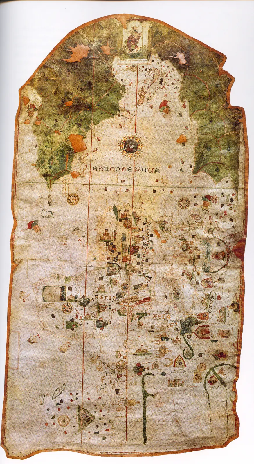
Juan de la Cosa's chart · 1500. It is not a map of the route of Columbus's first voyage. The image reproduces the chart preserved in the Naval Museum, MNM 257.
Cantino planisphere · 1502. The name corresponds to Alberto Cantino, who obtained the map, and does not identify the cartographer. The navigation lines are not itineraries of a specific expedition.
Caverio planisphere · Around 1505. The dating is approximate. It describes accumulated cartographic knowledge; it is not presented as a map carried aboard by Columbus or Ojeda.
Universalior cogniti orbis tabula · 1507–1508. The image preserves geographic hypotheses of the time. Its date is that of the cartography, not of a voyage represented.
Universalis cosmographia · 1507. The consultable reproduction does not imply that the navigators of any expedition used this map. Compare the geographic hypotheses with those of the Carta marina of 1516.
Fragment of the Piri Reis world map · 1513. Only a fragment survives. The place names and coastal outlines require specialized reading; the image is not a complete description of the world.
Carta marina navigatoria · 1516. The images and texts combine nautical information and the author's interpretations. It does not record the voyage of Solís or Magellan.
Americae sive novi orbis, nova descriptio · 1570. The depictions of the far south and the interior territories contain incomplete information and hypotheses of the period.
Art and memory
Other expeditions with shared protagonists
Sources and references
- [B146] Pinzón and the Hispanic roots of Brazil. Mariano Cuesta Domingo. Revista de Historia Militar, 116 (2014), pp. 103–154. Original record
- [B69] Juan de la Cosa's chart. Juan de la Cosa. 1500; MNM 257. Original record
- [B171] Treaty of Tordesillas. Crowns of Castile and Portugal. 7 June 1494; antecedent of the 16th-century demarcations. Original record
- [B20] Colección de los viages y descubrimientos que hicieron por mar los españoles desde fines del siglo XV, tomo III. Martín Fernández de Navarrete. Madrid, Imprenta Real, 1829. Original record
- [B5] De Orbe Novo, volumen 1. Pedro Mártir de Anglería; traducción de Francis A. MacNutt. Decades written from 1493; translation of 1912. Original record
- [B203] Historia general de los hechos de los castellanos en las islas i tierra firme del mar océano. Antonio de Herrera y Tordesillas. Work of 1601. Original record
- [B43] Vicente Yáñez Pinzón, Diccionario Biográfico Español. Real Academia de la Historia. n.d.; edition date not established. Original record
- [B66] Francisco de Orellana. Mariano Cuesta Domingo. Undated electronic edition; consulted on 2 November 2026. Original record
- Pinzón and the Hispanic roots of Brazil. Ministry of Defense, Revista de Historia Militar 116. Study discussing cartography, documentation and the location of the first landfall.
Documents and call numbers
- INDIFERENTE,415,L.1 · Capitulation with Pinzón
General bibliography guides further reading; it is not a pinpoint reference for every claim. Page, chapter and archival references are identified at the relevant passages.
Send comments to the author
Found an error or have information to contribute? Write privately to the author.