

Cantino planisphere
In this entry · 9 sections
1502 · Anonymous Portuguese cartographer · Estense University Library, Modena
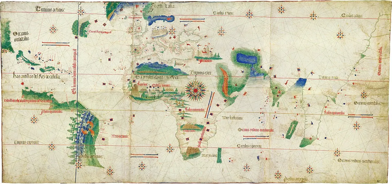
It allows comparison of the representations of Brazil, the Caribbean and the African coasts at the start of the 16th century.
How to interpret the map
The name corresponds to Alberto Cantino, who obtained the map, and does not identify the cartographer. The navigation lines are not itineraries of a specific expedition.
Provenance and rights
Anonymous Portuguese cartographer. Estense University Library, Modena. Provenance of the reproduction indicated in its link.
Institutional record · Public domain

Related expeditions
- First Voyage of Columbus: Discovery of America
- Second Voyage of Columbus: Colonization of the Antilles
- Third Voyage of Columbus: Discovery of the Mainland
- Ojeda's Expedition: Gulf of Venezuela
- Pinzón's Expedition: Discovery of Brazil and the Amazon
Related protagonists
- Alonso de Ojeda
- Cristóbal Colón
- Vicente Yáñez Pinzón
- Américo Vespucio
- Bartolomé Colón
- Diego Álvarez Chanca
- Juan de la Cosa
- Martín Alonso Pinzón
Maps
- Juan de la Cosa's chart
- Caverio planisphere
- Universalior cogniti orbis tabula
- Universalis cosmographia
- Fragment of the Piri Reis world map
- Carta marina navigatoria
- Americae sive quartae orbis partis nova et exactissima descriptio
- Americae sive novi orbis, nova descriptio
Show all links (9)
Art
- Portrait of Américo Vespucio
- Portrait of Bartolomé Colón
- Portrait of Juan de la Cosa
- Woodcuts of Columbus's letter (De insulis nuper inventis)
- Universal chart of Juan de la Cosa
- Americae pars quarta: the Columbian cycle
- Portrait of Christopher Columbus, frontispiece of Americae pars quinta
- Americae pars quinta: portrait of Christopher Columbus
Show all links (14)
- Hurricane during Columbus's second voyage
- Christopher Columbus informing King Ferdinand of the discovery of the Indies
- The Landing of Columbus, Oct. 11th 1492
- First Landing of Christopher Columbus in America
- To Christopher Columbus, on the Fourth Centenary of the discovery
- Portrait of a Man, thought to be Christopher Columbus
Related milestones
- Capitulations of Santa Fe
- Columbus reaches America
- Columbus reaches Cuba
- Columbus reaches Hispaniola
- Loss of the Santa María and La Navidad fort
- Return of Columbus’s first voyage
- Departure of Columbus’s second voyage
- Landings on Guadeloupe
Show all links (19)
- Sighting of Dominica
- Encounter at Salt River Bay
- Columbus’s expedition reaches Puerto Rico
- Establishment of La Isabela
- Columbus surveys Jamaica
- Treaty of Tordesillas
- Columbus’s fleet sights Trinidad
- Reconnaissance of the Gulf of Paria
- Voyage of Ojeda, Juan de la Cosa and Vespucci
- Pinzón reaches the Amazon estuary
- Juan de la Cosa’s world map
Mentioned in other entries
Una mención permite investigar una relación; no implica participación en la expedición ni acredita por sí sola el pasaje citado.
Sources of the related expeditions
- [B1] General and Natural History of the Indies: second part, first volume
- [B2] History of the Indies. Volume I
- [B5] De Orbe Novo, volumen 1
- [B8] Cristóbal Colón, Diccionario Biográfico Español
- [B9] Select Letters of Christopher Columbus
- [B11] Cronología General Iberoamericana: siglo XVI
- [B12] Historia del almirante don Cristóbal Colón
- [B14] Colección de los viages y descubrimientos, tomo II: Documentos de Colón y de las primeras poblaciones
Show all links (31)
- [B15] La Era de la Exploración: navegantes y conquistadores del siglo XVI
- [B18] Grants and confirmations of encomiendas: documentary guide
- [B20] Colección de los viages y descubrimientos que hicieron por mar los españoles desde fines del siglo XV, tomo III
- [B24] Historia de las Indias, volumen 2 de 5
- [B29] Historia general y natural de las Indias, islas y tierrafirme del mar océano (edición de la Real Academia de la Historia)
- [B36] Juan de la Cosa, Diccionario Biográfico Español
- [B37] Reivindicación burgalesa de Alonso de Ojeda, famoso conquistador y colonizador del Nuevo Mundo
- [B43] Vicente Yáñez Pinzón, Diccionario Biográfico Español
- [B65] Bartolomé Colón
- [B66] Francisco de Orellana
- [B67] Historia de las Indias, volumen 1 de 5
- [B69] Juan de la Cosa's chart
- [B75] Martín Alonso Pinzón
- [B82] Explorers and conquerors of the Indies: geographical accounts
- [B85] La reescritura del Diario de a bordo y la figura de Cristóbal Colón en The Accidental Indies de Robert Finley
- [B87] New documented list of Columbus’s crew in 1492: notes
- [B96] Capitulations of Santa Fe: registry copy
- [B121] Juan de la Cosa: the historical cartography of the Spanish discoveries
- [B131] Juan de la Cosa: voyages and documentation
- [B146] Pinzón and the Hispanic roots of Brazil
- [B171] Treaty of Tordesillas
- [B173] The Letters of Amerigo Vespucci, and Other Documents Illustrative of His Career
- [B203] Historia general de los hechos de los castellanos en las islas i tierra firme del mar océano
Send comments to the author
Found an error or have information to contribute? Write privately to the author.