

First Voyage of Columbus: Discovery of America
In this entry · 21 sections
- Context
- Stages
- Events of this expedition
- Route data
- Outcome
- Limits of the evidence
- Expedition facts
- Organisation
- Objectives
- Encounters and societies
- Ships and crew
- People and societies
- Related people
- Related cartography
- Art and memory
- Other expeditions with shared protagonists
- Mentioned in other entries
- Sources and references
- Further reading and comparison
- Examine and compare documents
- Sources of the related expeditions
Expedition · 1492. Cristóbal Colón.
On 3 August 1492 the nao Santa María and the caravels Pinta and Niña leave Palos under Christopher Columbus. The project seeks to reach Asia westwards. The brothers Martín Alonso and Vicente Yáñez Pinzón command the caravels. [B8] [B43]
After repairing the Pinta and taking on supplies in the Canaries, the fleet sets out into the Atlantic at the start of September. More than a month later, on 12 October, it lands on an island in the Bahamas, Guanahaní, whose present-day identification remains disputed. Columbus goes on to Cuba, believing himself close to Asia, and then to Hispaniola, where the Santa María runs aground on Christmas Eve. From her remains the fort of La Navidad is built, where some forty men stay. [B8] [B2]¶ [B9]
The caravels return separately. The Niña reaches Palos on 15 March 1493 after a stop in Lisbon. Columbus has not reached Asia, but he has opened sustained communication between Europe and the Caribbean. La Navidad will not survive: when he returns on his second voyage he will find it destroyed. [B43] [B8]
Context
The Castilian Crown backed a western route to Asia through the Capitulations of Santa Fe. The project relied on resources of the monarchy, shipowners and maritime networks of Andalusia; it set out toward inhabited territories with histories of their own. [B8] [B75] [B9]
Stages
- August 3, 1492, Palos de la Frontera: Departure of the fleet. [B8]
- August–September 1492, Canary Islands: Repair and provisioning before the crossing. [B8]
- October 12, 1492, Guanahani: First documented landing of the voyage in the Bahamas. [B8]
- October 1492, Cuba: Survey of coasts and search for information about Asia. [B8]
- December 1492, Hispaniola: vicinity of La Navidad: Loss of the Santa María and construction of La Navidad; some of the expedition members remained there. [B2]
- March 15, 1493, Palos: Return of the caravels after separate stopovers in the Atlantic. [B43]
Events of this expedition
Route data
- The nao Santa María and the caravels Pinta and Niña
- About 90 men according to Ferdinand Columbus
- 39 men stayed in the fort of La Navidad
Outcome
A sustained Atlantic connection between Europe and the Caribbean was opened. [B9]¶ [B8]
The post left at La Navidad did not survive until the second voyage arrived; later colonization should not be confused with a continuous settlement since 1492. [B8]
Limits of the evidence
The Guanahani marker is indicative and does not identify a landing with archaeological precision.
The original logbook is not preserved; the known text depends mainly on Las Casas's transmission. Imagined words of the participants are not reproduced as testimony. [B85]
Expedition facts
| Date | 1492 |
|---|---|
| Leader | Cristóbal Colón |
| Departure | Palos de la Frontera |
| Destination | — |
| Period | 1492–1493 |
Organisation
The fleet left Palos on 3 August 1492 and completed its preparation in the Canaries. Financing and recruitment combined royal initiative and local participation; it was not an enterprise carried out by Columbus alone. [B8] [B75]
Objectives
- To reach Asia by sailing west [B8]
- To explore and claim territories and commercial possibilities for the Crown [B9]
Encounters and societies
In the Santángel letter Columbus states that he forcibly took inhabitants of the first island so that they would learn his language and provide information. This is his account of the capture, not the voice of the captives. [B9]
Ships and crew
| Ship | Captain | Master | Pilot | Reference |
|---|---|---|---|---|
| Santa María | Cristóbal Colón | Juan de la Cosa | Assignment disputed: Sancho Ruiz de Gama or Pedro Alonso Niño | Alice Bache Gould, New documented list of Columbus's crew in 1492, notes 2–4 [B87] |
| Pinta | Martín Alonso Pinzón | Francisco Martín Pinzón | Cristóbal García Sarmiento | Alice Bache Gould, New documented list…, notes 2–4 [B87] |
| Niña (Santa Clara) | Vicente Yáñez Pinzón | Juan Niño | Assignment disputed: Pedro Alonso Niño or Sancho Ruiz de Gama | Alice Bache Gould, New documented list…, notes 2–4 [B87] |
People and societies
- Cristóbal Colón: Admiral and head of the expedition [B8]
- Martín Alonso Pinzón: Captain of the Pinta [B8]
- Vicente Yáñez Pinzón: Captain of the Niña [B43]
- Juan de la Cosa: Master and owner of the Santa María [B36]
- Guacanagarí: Taíno ruler connected with the establishment of La Navidad [B2]
Related people
Related cartography
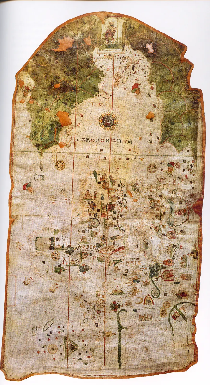
Juan de la Cosa's chart · 1500. It is not a map of the route of Columbus's first voyage. The image reproduces the chart preserved in the Naval Museum, MNM 257.
Cantino planisphere · 1502. The name corresponds to Alberto Cantino, who obtained the map, and does not identify the cartographer. The navigation lines are not itineraries of a specific expedition.
Caverio planisphere · Around 1505. The dating is approximate. It describes accumulated cartographic knowledge; it is not presented as a map carried aboard by Columbus or Ojeda.
Universalior cogniti orbis tabula · 1507–1508. The image preserves geographic hypotheses of the time. Its date is that of the cartography, not of a voyage represented.
Universalis cosmographia · 1507. The consultable reproduction does not imply that the navigators of any expedition used this map. Compare the geographic hypotheses with those of the Carta marina of 1516.
Fragment of the Piri Reis world map · 1513. Only a fragment survives. The place names and coastal outlines require specialized reading; the image is not a complete description of the world.
Carta marina navigatoria · 1516. The images and texts combine nautical information and the author's interpretations. It does not record the voyage of Solís or Magellan.
Americae sive quartae orbis partis nova et exactissima descriptio · 1562. The copy in the image is reproduced from Wikimedia Commons; the institutional record allows comparison with another copy of the same work. It is not a reconstruction of all the routes.
Americae sive novi orbis, nova descriptio · 1570. The depictions of the far south and the interior territories contain incomplete information and hypotheses of the period.
Descriptionis Ptolemaicae augmentum: set of plates · Atlas of 1597; record of a 1964 facsimile; montage of reproductions with no precise date. The linked record describes a 1964 facsimile with an introduction by R. A. Skelton. The image is a montage of plates, not a single historical sheet. To cite a specific region its plate and edition must be located.
Art and memory
- Portrait of Juan de la Cosa · Date not established
- Woodcuts of Columbus's letter (De insulis nuper inventis) · 1493–1494
- Universal chart of Juan de la Cosa · 1500
- Americae pars quarta: the Columbian cycle · 1594
- Portrait of Christopher Columbus, frontispiece of Americae pars quinta · 1595
- Americae pars quinta: portrait of Christopher Columbus · 1595
- Christopher Columbus informing King Ferdinand of the discovery of the Indies · 1649
- The Landing of Columbus, Oct. 11th 1492 · 1846
- First Landing of Christopher Columbus in America · 1862
- To Christopher Columbus, on the Fourth Centenary of the discovery · 1892
Other expeditions with shared protagonists
- Ojeda's Expedition: Gulf of Venezuela
- Pinzón's Expedition: Discovery of Brazil and the Amazon
- Columbus's fall as governor
- Expedition of Rodrigo de Bastidas and Juan de la Cosa
- Juan de la Cosa's Expedition to Urabá
- Columbus's return and the death of Isabella of Castile
- Joint Expedition of Solís and Vicente Yáñez Pinzón
- Ojeda's Expedition to Nueva Andalucía (1509–1510)
Mentioned in other entries
Una mención permite investigar una relación; no implica participación en la expedición ni acredita por sí sola el pasaje citado.
Sources and references
- [B9] Select Letters of Christopher Columbus. Cristóbal Colón; edición de R. H. Major. Hakluyt Society edition (nineteenth century). Original record
- [B96] Capitulations of Santa Fe: registry copy. Crown and Christopher Columbus; register of the secretary Juan de Coloma. 17 April 1492; antecedent of the 16th-century expeditions. Original record
- [B2] History of the Indies. Volume I. Bartolomé de las Casas. 16th-century text; Madrid edition, 1875; digitization, 2007. Original record
- [B12] Historia del almirante don Cristóbal Colón. Hernando Colón. Mid-sixteenth-century work; Madrid edition. Original record
- [B14] Colección de los viages y descubrimientos, tomo II: Documentos de Colón y de las primeras poblaciones. Martín Fernández de Navarrete. Edition of 1859. Original record
- [B5] De Orbe Novo, volumen 1. Pedro Mártir de Anglería; traducción de Francis A. MacNutt. Decades written from 1493; translation of 1912. Original record
- [B67] Historia de las Indias, volumen 1 de 5. Bartolomé de las Casas. Work written between 1527 and 1561; edition of 1875. Original record
- [B29] Historia general y natural de las Indias, islas y tierrafirme del mar océano (edición de la Real Academia de la Historia). Gonzalo Fernández de Oviedo; edition by José Amador de los Ríos. Madrid edition, 1851. Original record
- [B8] Cristóbal Colón, Diccionario Biográfico Español. Juan Pérez de Tudela y Bueso · Real Academia de la Historia. n.d.; edition date not established. Original record
- [B43] Vicente Yáñez Pinzón, Diccionario Biográfico Español. Real Academia de la Historia. n.d.; edition date not established. Original record
- [B75] Martín Alonso Pinzón. Jesús Varela Marcos. Undated electronic edition; consulted on 2 November 2026. Original record
- [B36] Juan de la Cosa, Diccionario Biográfico Español. Real Academia de la Historia. n.d.; edition date not established. Original record
- [B87] New documented list of Columbus’s crew in 1492: notes. Alice Bache Gould. Historical study; digital edition from the Biblioteca Virtual Miguel de Cervantes. Original record
- [B85] La reescritura del Diario de a bordo y la figura de Cristóbal Colón en The Accidental Indies de Robert Finley. Ana Paulina Gil Vargas. 2009. Original record
- The Columbian voyages: synthesis and documents. Ministry of Culture / State Archives. Institutional synthesis; it distinguishes the four voyages and their dates.
- Columbus's letters: first announcement and account of the third voyage. Biblioteca Virtual Miguel de Cervantes. Edition of period texts; the author presents his voyages to his addressees and justifies his conduct.
- Evaluation of the historic and archaeological site of La Isabela. ICOMOS / UNESCO, 2021 evaluation, nomination 1628. It distinguishes La Isabela, in the north of the present-day Dominican Republic, from La Navidad, located to the west. It does not turn the regional setting of the fort into an exact archaeological coordinate.
Documents and call numbers
- ACA,CANCILLERÍA,Registros,3569,fols.135v-136v · Capitulations of Santa Fe
- MSS/7302 · Columbus's logbook (Las Casas copy)
- PATRONATO,295,N.1 / INC,5-3-V.14 · Columbus's letter to Luis de Santángel
General bibliography guides further reading; it is not a pinpoint reference for every claim. Page, chapter and archival references are identified at the relevant passages.
Further reading and comparison
- Second Voyage of Columbus: Colonization of the Antilles · 1493
- Exploration of southern Cuba and Jamaica · 1494
- Expeditions on Hispaniola and the repartimiento system · 1495
- Return and outcome of Columbus's second voyage · 1496
- Third Voyage of Columbus: Discovery of the Mainland · 1498
- Fourth Voyage of Christopher Columbus · 1502
Examine and compare documents
- Columbus’s four voyages: different documents — Did Columbus write every account of the four voyages? ·
Documentary supplements with their own review scope; they do not certify a complete collation of this entry.
Send comments to the author
Found an error or have information to contribute? Write privately to the author.