

Expedition of the Nodal Brothers: Survey of the Strait of Magellan
In this entry · 18 sections
- Context
- Stages
- Events of this expedition
- Route data
- Outcome
- Limits of the evidence
- Expedition facts
- Organisation
- Objectives
- Encounters and societies
- Ships and crew
- People and societies
- Related people
- Related cartography
- Art and memory
- Sources and references
- Examine and compare documents
- Sources of the related expeditions
Expedition · 1618. Bartolomé García de Nodal and Gonzalo García de Nodal.
Martínic dates departure from Lisbon to 27 September 1618 with Nuestra Señora de Atocha and Nuestra Señora del Buen Suceso, not Santo Domingo. Bartolomé and Gonzalo García de Nodal commanded the vessels; Diego Ramírez de Arellano was pilot and cosmographer. The commission sought to verify Le Maire and Schouten’s navigation. [B139] [B180]
The study reconstructs Rio de Janeiro, Buen Suceso, Le Maire and Cape Horn. For the Diego Ramírez Islands, the facsimile distinguishes a sighting on 10 February from the naming on the 12th. The return through the Strait of Magellan completed the circuit around Tierra del Fuego. [B139] [B112]
Martínic distinguishes Gonzalo’s departure to report to the king on 7 July from the ships’ arrival at Sanlúcar on the 9th; he states that no crew member died. The printed account of 1621 and Ramírez’s sailing directions are different testimonies; the local copy of the account is a reprint. [B139] [B177] [B180]
Context
The monarchy wanted to know the passages south of Tierra del Fuego and assess their implications for navigation and the defense of the Pacific. The campaign had a specific cartographic and reconnaissance objective. [B139]
Stages
- September 27, 1618, Lisboa: Departure according to the chronology of the study used. [B139]
- 1618, Brazil: Stopovers before heading for the southern passages. [B139]
- 1619, Tierra del Fuego and Cape Horn: Passage to the Pacific south of the archipelago. [B139]
- February 1619, Diego Ramírez Islands: Survey of the southern archipelago. [B112]
- 1619, Strait of Magellan: Return to the Atlantic and closing of the circumnavigation of Tierra del Fuego. [B139]
- July 1619, Iberian Peninsula: Martínic distinguishes Gonzalo’s landing near Cape St Vincent on 7 July to report to the king in Lisbon from the ships’ arrival at Sanlúcar on the 9th. [B139] [B180]
Events of this expedition
Route data
- Caravels Nuestra Señora de Atocha and Nuestra Señora del Buen Suceso.
- First circumnavigation of Tierra del Fuego; no crew member died.
- The cosmographer Diego Ramírez de Arellano gave his name to the southernmost islands then known.
Outcome
Observations were obtained to compare the southern routes and confirm the insularity of Tierra del Fuego. [B139]
The Nodal account was published in 1621; Ramírez’s sailing directions have a different transmission. The facsimile available here is a later reprint. [B177] [B180]
Limits of the evidence
Gonzalo’s landing to report to the king is distinguished from the two ships’ arrival at Sanlúcar. [B139]
The campaign ended in 1619: the atlas includes it within its 1492–1619 scope, although it extends beyond the strict sixteenth century. [B139]
Expedition facts
| Date | 1618 |
|---|---|
| Leader | Bartolomé García de Nodal and Gonzalo García de Nodal |
| Departure | Not specified in this entry |
| Destination | — |
| Period | 1618–1619; account printed in 1621 |
Organisation
Two vessels left Lisbon in September 1618. The organization stressed sailing in coordination and recording coasts, depths and conditions of the passages. [B139]
Objectives
- To survey the Le Maire passage and Cape Horn [B139]
- To compare its navigation with that of the Strait of Magellan [B139]
- To gather observations and rutters of the southern region [B139]
Encounters and societies
Martínic describes the encounter at Buen Suceso, canoe peoples’ dwellings in the strait and the March contact with Patagonians. Direct encounters are distinguished from observed traces of occupation. [B139]
Ships and crew
| Ship | Captain | Master | Pilot | Reference |
|---|---|---|---|---|
| Nuestra Señora de Atocha | Bartolomé García de Nodal | Not documented here | Not documented here | Revista General de Marina, August–September 2019, pp. 395–396 [B139] |
| Nuestra Señora del Buen Suceso | Gonzalo García de Nodal | Not documented here | Not documented here | Revista General de Marina, August–September 2019, pp. 395–396 [B139] |
Nuestra Señora de Atocha: Diego Ramírez de Arellano was the cosmographer and chief pilot of the expedition. The allocation of the remaining pilots between the two caravels is not completed here.
People and societies
- Bartolomé García de Nodal: In charge of one of the vessels and of the joint command [B139]
- Gonzalo García de Nodal: In charge of the other vessel [B139]
- Diego Ramírez de Arellano: Pilot and cosmographer; he made observations and a rutter [B180]
Related people
Related cartography
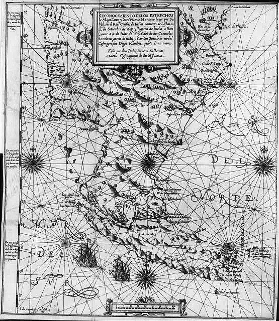
Straits of Magellan and San Vicente: the Nodal account · 1621; documents the voyage of 1618–1619. It is included as a testimony published after the end of the atlas. The Library of Congress reproduction is black and white; its record warns of old unverified metadata.
Art and memory
- Navigation manual · 1606
Sources and references
- [B112] Account of the voyage of Captains Bartholome Garcia de Nodal and Gonzalo de Nodal to the new Strait of San Vicente. Bartolomé García de Nodal and Gonzalo de Nodal, brothers, natives of Pontevedra. Voyage of 1618–1619; work of 1621, Cádiz reprint, 1766. Original record
- [B191] Filólogos en la mar: hacia una edición crítica digital de los manuscritos de Diego Ramírez de Arellano sobre los estrechos de Magallanes y Mayre. Iole Maria Caterina Scamuzzi y Roberto Rosselli Del Turco. 2025. Original record
- [B123] The maps and the first circumnavigation. National Geographic Institute. Contemporary catalog on the cartography of the 1519–1522 expedition. Original record
- [B139] Cuatro siglos del viaje de los hermanos Nodal a la Tierra del Fuego (1618–1619). Mateo Martinic B.. 2018, pp. 7–23. Original record
- [B180] Diego Ramírez de Arellano. Cristina González Hernández. Undated electronic edition; consulted on 2 November 2026. Original record
- [B177] Bartolomé García de Nodal. Carlos Sixirei Paredes. Undated electronic edition; consulted on 2 November 2026. Original record
- Account of the voyage of the Nodal brothers, Madrid, 1621. Foral Library of Bizkaia, Lau Haizeetara. Period edition with folded map. The 1621 publication is later than the campaign of 1618–1619.
- Study and rutter of the Nodal brothers. UNED, institutional repository; David Rodríguez Couto. The rutter is dated from 27 September 1618 to 9 July 1619.
Documents and call numbers
- INDIFERENTE,427 · Account of the Nodal expedition
General bibliography guides further reading; it is not a pinpoint reference for every claim. Page, chapter and archival references are identified at the relevant passages.
Examine and compare documents
- The Nodals: from diary entry to map — How do sighting, recognising and naming an island differ? ·
- Pacification: legislation and non-compliance — Does changing a name establish that violence ceased? ·
- Nodal: the voyage account and additions to the volume — Was everything in this volume written by the Nodal brothers? ·
Documentary supplements with their own review scope; they do not certify a complete collation of this entry.
Send comments to the author
Found an error or have information to contribute? Write privately to the author.