

Straits of Magellan and San Vicente: the Nodal account
In this entry · 8 sections
1621; documents the voyage of 1618–1619 · Pedro Teixeira Albernaz; engraving by Jean de Courbes, from the surveys of the expedition · Library of Congress, Prints and Photographs Division
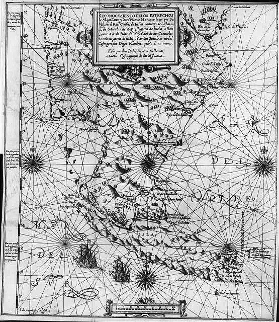
Map published with the account of the voyage of the Nodal brothers, which allows study of the southern passages and Tierra del Fuego.
How to interpret the map
It is included as a testimony published after the end of the atlas. The Library of Congress reproduction is black and white; its record warns of old unverified metadata.
Provenance and rights
Pedro Teixeira Albernaz; engraving by Jean de Courbes, from the surveys of the expedition. Library of Congress, Prints and Photographs Division. Provenance of the reproduction indicated in its link.
Institutional record · No known publication restrictions, according to the Library of Congress
Related expeditions
- Expedition of the Nodal Brothers: Survey of the Strait of Magellan
- First Circumnavigation: The Magellan–Elcano Expedition
Related protagonists
- Bartolomé García de Nodal
- Fernando de Magallanes
- Gonzalo García de Nodal
- Gonzalo Gómez de Espinosa
- Juan Sebastián Elcano
- Antonio Pigafetta
- Diego Ramírez de Arellano
- Juan Gómez de Espinosa
Show all links (9)
Maps
- Miller Atlas: world map
- Universal chart of Diego Ribero: reproduction
- Nautical planisphere of Lopo Homem
- Universale descrittione di tutta la terra conosciuta fin qui
- Nova et aucta orbis terrae descriptio
- Africae tabula nova
- Asiae nova descriptio
- Maris Pacifici
Show all links (10)
Art
- Coat of arms of Gonzalo Gómez de Espinosa
- Americae sive quartae orbis partis nova et exactissima descriptio
- Description of the West Indies and title pages of the Décadas
- Navigation manual
- Portrait of Ferdinand Magellan
- Imaginary portrait of Juan Sebastián Elcano
Related milestones
- Magellan begins the first circumnavigation
- Encounters in Patagonia during the winter stay
- Mutiny at San Julián
- Magellan finds the strait
- Magellan’s fleet reaches Guam
- The expedition lands at Homonhon
- Magellan and Rajah Humabon at Cebu
- Battle of Mactan and death of Magellan
Show all links (12)
Sources of the related expeditions
- [B3] The Spanish Lake
- [B4] España y el Pacífico: un breve repaso a las expediciones españolas de los siglos XVI al XVIII
- [B6] Spanish discoveries in the South Sea
- [B7] Los hallazgos españoles en el Pacífico
- [B13] Relatos de viaje del siglo XVI
- [B21] Documentation of Magellan's fleet
- [B23] The First Voyage Round the World, by Magellan
- [B28] Colección de los viages y descubrimientos: Expediciones al Maluco. Viage de Magallanes y de Elcano
Show all links (29)
- [B30] First Voyage Around the World
- [B35] First Voyage Around the World: critical edition
- [B38] La Relación del primer viaje alrededor del mundo de Antonio Pigafetta y sus traducciones al español
- [B39] Reconstruction of the Trinidad’s route: the Navy’s KMZ file
- [B40] Primer viaje alrededor del mundo: edición de Leoncio Cabrero
- [B41] Punzorol’s letter from Tidore: critical edition and Spanish translation
- [B42] Gonzalo Gómez de Espinosa’s letter to Charles I about the Trinidad
- [B44] Elcano’s letter to the emperor (1522): copy and AGI transcription
- [B45] Pedro Gómez: servant aboard the Trinidad
- [B46] The crews of the first circumnavigation
- [B47] Virtual navigation of Gonzalo Gómez de Espinosa: attempted eastward return in 1522
- [B48] Gonzalo Gómez de Espinosa, Diccionario Biográfico Español
- [B49] Historia general y natural de las Indias, tomo II: primera parte de la segunda parte
- [B112] Account of the voyage of Captains Bartholome Garcia de Nodal and Gonzalo de Nodal to the new Strait of San Vicente
- [B123] The maps and the first circumnavigation
- [B139] Cuatro siglos del viaje de los hermanos Nodal a la Tierra del Fuego (1618–1619)
- [B156] Study and rutter of the Nodal brothers
- [B177] Bartolomé García de Nodal
- [B180] Diego Ramírez de Arellano
- [B181] Account of the voyage of the Nodal brothers, Madrid, 1621
- [B191] Filólogos en la mar: hacia una edición crítica digital de los manuscritos de Diego Ramírez de Arellano sobre los estrechos de Magallanes y Mayre
Send comments to the author
Found an error or have information to contribute? Write privately to the author.