

Third Voyage of Columbus: Discovery of the Mainland
In this entry · 19 sections
- Context
- Stages
- Events of this expedition
- Route data
- Outcome
- Limits of the evidence
- Expedition facts
- Organisation
- Objectives
- Encounters and societies
- Recorded vessels
- People and societies
- Related people
- Related cartography
- Art and memory
- Other expeditions with shared protagonists
- Sources and references
- Further reading and comparison
- Examine and compare documents
Expedition · 1498. Cristóbal Colón.
On 30 May 1498 [B9]¶ Columbus sails from Sanlúcar de Barrameda with six ships on his third voyage. He wants to expand the results of the earlier ones and at the same time maintain his increasingly questioned authority. He divides the fleet in the Canaries: part will go directly to Hispaniola and he, with the rest, will take a route further south. [B8]
At the end of July he sights the island of Trinidad. Then he enters the Gulf of Paria, where he observes that the waters are fresh and understands that there must be an enormous river and therefore a land of great extent. He writes that it is a new world, or even the earthly Paradise. [B9]¶ [B8]
On Hispaniola, Francisco Roldán’s rebellion against Bartolomé Columbus’s authority worsens the crisis of government. The Crown sends investigating judge Francisco de Bobadilla, who arrests the three brothers and sends them to Castile in 1500. Although released, Christopher does not recover the governorship of the Indies. [B8]
Context
The enterprise sought to extend the results of the earlier voyages and maintain Columbus's authority. In the Caribbean there were conflicts with the settlers and growing pressure on the Indigenous populations. [B8] [B8]
Stages
- May 30, 1498, Sanlúcar: Departure of the third voyage. [B9]
- 1498, Canary Islands and Cape Verde: Stopovers before the southern crossing. [B9]
- July–August 1498, Trinidad and Paria: Survey of coasts and observation of large inflows of fresh water. [B8]
- 1498, Gulf of Paria: Contact with territories of the South American continent. [B8]
- 1498–1500, Hispaniola: Negotiations and conflicts of government; Bobadilla's intervention. [B8]
- November 1500, Iberian Peninsula: Columbus and his brothers were sent in custody. [B65]
Events of this expedition
Route data
- 6 ships: three followed Columbus to the south and three went straight to Hispaniola with provisions.
- The enormous discharge of fresh water from the Orinoco convinced Columbus he was facing the “mainland” (tierra firme).
- On Hispaniola he found Francisco Roldán's rebellion; in 1500 Bobadilla sent him to Castile in custody.
Outcome
The voyage provided information on the South American coasts and on the relationship between great rivers and a continental landmass. [B8]
The Crown removed Columbus from effective government of Hispaniola; this did not mean the abandonment of expansion. [B8]
Limits of the evidence
Columbus's interpretation of those lands was not equivalent to a modern identification of the continent.
His letter is an interested presentation of the results. It avoids asserting that it was the first European contact with any point of continental America.
Expedition facts
| Date | 1498 |
|---|---|
| Leader | Cristóbal Colón |
| Departure | Sanlúcar de Barrameda |
| Destination | — |
| Period | 1498–1500 |
Organisation
It sailed from Sanlúcar on 30 May 1498 with six ships. The expedition split: some vessels headed for Hispaniola and others continued with Columbus on a more southerly course. [B9]¶ [B8]
Objectives
- To seek new lands and possibilities of access to Asia [B8]
- To strengthen the government and supply of the Caribbean settlements [B8]
Encounters and societies
Pérez de Tudela places Roldán’s rebellion within the conflict with Bartolomé Columbus’s government and describes demands for land and shipments of enslaved Indigenous people. This is the study’s interpretation, distinct from the voices of the affected groups. [B8]
Recorded vessels
- Six ships on departure; part was sent directly to Hispaniola [B8]
People and societies
- Cristóbal Colón: Head of the voyage and governor [B8]
- Bartolomé Colón: Governing responsibilities on Hispaniola [B8]
- Francisco Roldán: Led a rebellion of settlers [B8]
- Francisco de Bobadilla: Investigating judge sent by the Crown in 1500 [B8]
Related people
Related cartography
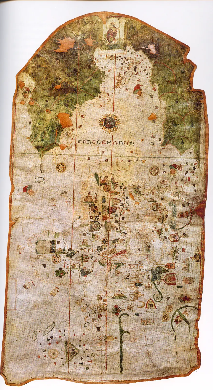
Juan de la Cosa's chart · 1500. It is not a map of the route of Columbus's first voyage. The image reproduces the chart preserved in the Naval Museum, MNM 257.
Cantino planisphere · 1502. The name corresponds to Alberto Cantino, who obtained the map, and does not identify the cartographer. The navigation lines are not itineraries of a specific expedition.
Caverio planisphere · Around 1505. The dating is approximate. It describes accumulated cartographic knowledge; it is not presented as a map carried aboard by Columbus or Ojeda.
Universalior cogniti orbis tabula · 1507–1508. The image preserves geographic hypotheses of the time. Its date is that of the cartography, not of a voyage represented.
Universalis cosmographia · 1507. The consultable reproduction does not imply that the navigators of any expedition used this map. Compare the geographic hypotheses with those of the Carta marina of 1516.
Fragment of the Piri Reis world map · 1513. Only a fragment survives. The place names and coastal outlines require specialized reading; the image is not a complete description of the world.
Carta marina navigatoria · 1516. The images and texts combine nautical information and the author's interpretations. It does not record the voyage of Solís or Magellan.
Americae sive quartae orbis partis nova et exactissima descriptio · 1562. The copy in the image is reproduced from Wikimedia Commons; the institutional record allows comparison with another copy of the same work. It is not a reconstruction of all the routes.
Americae sive novi orbis, nova descriptio · 1570. The depictions of the far south and the interior territories contain incomplete information and hypotheses of the period.
Descriptionis Ptolemaicae augmentum: set of plates · Atlas of 1597; record of a 1964 facsimile; montage of reproductions with no precise date. The linked record describes a 1964 facsimile with an introduction by R. A. Skelton. The image is a montage of plates, not a single historical sheet. To cite a specific region its plate and edition must be located.
Art and memory
- Portrait of Bartolomé Colón · 1889 (reproduced edition)
- Universal chart of Juan de la Cosa · 1500
- Portrait of a Man, thought to be Christopher Columbus · Before 1519
Other expeditions with shared protagonists
- Reinforcement of Bartholomew Columbus on Hispaniola
- Establishment and founding of Santo Domingo (1496–1498)
- Columbus's fall as governor
- Columbus's return and the death of Isabella of Castile
Sources and references
- [B9] Select Letters of Christopher Columbus. Cristóbal Colón; edición de R. H. Major. Hakluyt Society edition (nineteenth century). Original record
- [B2] History of the Indies. Volume I. Bartolomé de las Casas. 16th-century text; Madrid edition, 1875; digitization, 2007. Original record
- [B12] Historia del almirante don Cristóbal Colón. Hernando Colón. Mid-sixteenth-century work; Madrid edition. Original record
- [B14] Colección de los viages y descubrimientos, tomo II: Documentos de Colón y de las primeras poblaciones. Martín Fernández de Navarrete. Edition of 1859. Original record
- [B8] Cristóbal Colón, Diccionario Biográfico Español. Juan Pérez de Tudela y Bueso · Real Academia de la Historia. n.d.; edition date not established. Original record
- [B65] Bartolomé Colón. Jesús Varela Marcos. Undated electronic edition; consulted on 2 November 2026. Original record
- The Columbian voyages: synthesis and documents. Ministry of Culture / State Archives. Institutional synthesis; it distinguishes the four voyages and their dates.
- Columbus's letters: first announcement and account of the third voyage. Biblioteca Virtual Miguel de Cervantes. Edition of period texts; the author presents his voyages to his addressees and justifies his conduct.
Documents and call numbers
- PATRONATO,295,N.7 · Account of the third voyage
General bibliography guides further reading; it is not a pinpoint reference for every claim. Page, chapter and archival references are identified at the relevant passages.
Further reading and comparison
- First Voyage of Columbus: Discovery of America · 1492
- Second Voyage of Columbus: Colonization of the Antilles · 1493
- Exploration of southern Cuba and Jamaica · 1494
- Expeditions on Hispaniola and the repartimiento system · 1495
- Return and outcome of Columbus's second voyage · 1496
- Fourth Voyage of Christopher Columbus · 1502
Examine and compare documents
- Columbus’s four voyages: different documents — Did Columbus write every account of the four voyages? ·
Documentary supplements with their own review scope; they do not certify a complete collation of this entry.
Send comments to the author
Found an error or have information to contribute? Write privately to the author.