

Americae sive quartae orbis partis nova et exactissima descriptio
In this entry · 8 sections
1562 · Diego Gutiérrez; engraving by Hieronymus Cock · Library of Congress; reproduction of the British Library copy on Wikimedia Commons
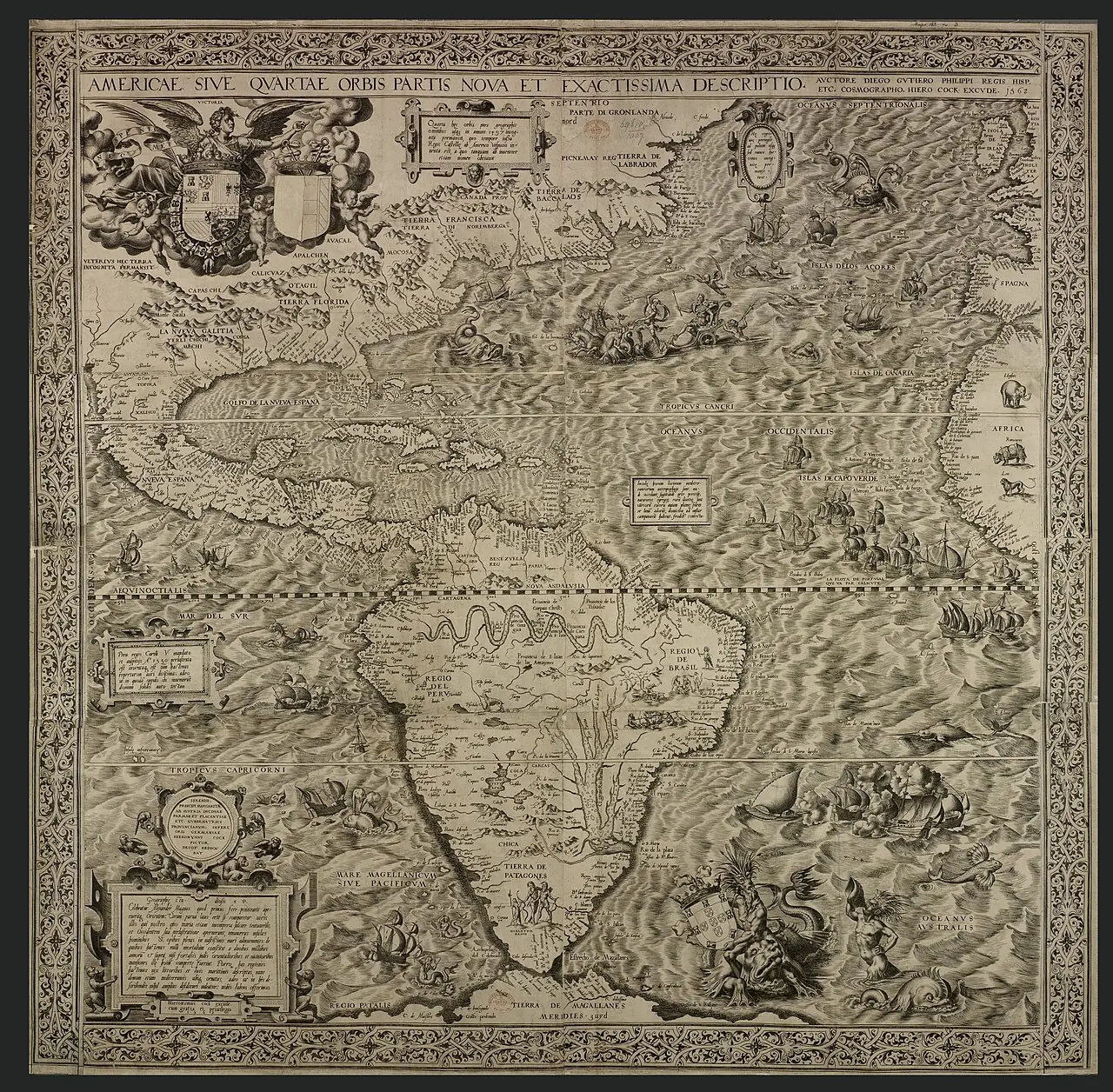
Large map of America for studying the representation of the continent and the claims to power in the age of Philip II.
How to interpret the map
The copy in the image is reproduced from Wikimedia Commons; the institutional record allows comparison with another copy of the same work. It is not a reconstruction of all the routes.
Provenance and rights
Diego Gutiérrez; engraving by Hieronymus Cock. Library of Congress; reproduction of the British Library copy on Wikimedia Commons. Provenance of the reproduction indicated in its link.
Institutional record · Public domain

Related expeditions
- First Voyage of Columbus: Discovery of America
- Second Voyage of Columbus: Colonization of the Antilles
- Third Voyage of Columbus: Discovery of the Mainland
- Córdoba's Expedition: Discovery of Yucatán
- Grijalva's Expedition: Contact with the Aztec Empire
- Conquest of Mexico: fall of the Aztec Empire
- Solís's Expedition: Discovery of the Río de la Plata
- Mendoza's Expedition: First Founding of Buenos Aires
- Orellana's Second Expedition: Nueva Andalucía
- Discovery of the Pacific Ocean
- Start of the conquest of Peru
- Entry of Gonzalo Pizarro and Orellana's Descent (1541–1542)
Related protagonists
- Cristóbal Colón
- Francisco de Orellana
- Francisco Hernández de Córdoba
- Francisco Pizarro
- Hernán Cortés
- Juan de Grijalva
- Juan Díaz de Solís
- Pedro de Mendoza
Show all links (34)
- Vasco Núñez de Balboa
- Alonso de Ojeda
- Ana de Ayala
- Antón de Alaminos
- Bartolomé Colón
- Bernal Díaz del Castillo
- Diego Álvarez Chanca
- Diego de Almagro
- Domingo Martínez de Irala
- Francisco de Montejo
- Francisco de Torres
- Francisco de Xerez
- Gaspar de Carvajal
- Gaspar de Espinosa
- Gonzalo Pizarro
- Hernando de Luque
- Jerónimo de Aguilar
- Juan de Ayolas
- Juan de la Cosa
- Juan Díaz
- Malintzin o doña Marina
- Martín Alonso Pinzón
- Pedro de Alvarado
- Pedro de Solís Barrasa
- Ulrico Schmidel
- Vicente Yáñez Pinzón
Maps
- Juan de la Cosa's chart
- Cantino planisphere
- Caverio planisphere
- Universalior cogniti orbis tabula
- Universalis cosmographia
- Fragment of the Piri Reis world map
- Carta marina navigatoria
- Miller Atlas: world map
Show all links (16)
- Tenochtitlan and the Gulf of Mexico
- Nautical planisphere of Lopo Homem
- La descrittione di tutto il Peru
- Americae sive novi orbis, nova descriptio
- Painting of Teozacoalco and documentation of its geographic report
- Descriptionis Ptolemaicae augmentum: set of plates
- Granata Nova et California
- Hispaniae Novae sive Magnae, recens et vera descriptio
Art
- Portrait of Bartolomé Colón
- Portrait of Diego de Almagro
- Portrait of Domingo Martínez de Irala
- Portrait of Francisco de Orellana
- Portrait of Francisco Pizarro
- Portrait of Hernán Cortés
- Portrait of Juan de Ayolas
- Portrait of Juan de Grijalva
Show all links (51)
- Portrait of Juan de la Cosa
- Portrait of Malintzin o doña Marina
- Portrait of Pedro de Alvarado
- Portrait of Ulrico Schmidel
- Portrait of Vasco Núñez de Balboa
- Woodcuts of Columbus's letter (De insulis nuper inventis)
- Universal chart of Juan de la Cosa
- Plan of Tenochtitlan from the second Letter of Relation
- Azcatitlan Codex: arrival of Cortés and the Spaniards
- Huexotzinco Codex
- Lienzo de Tlaxcala
- Massacre of Cholula, from the Lienzo de Tlaxcala
- La Descrittione di tutto il Peru
- Americae sive quartae orbis partis nova et exactissima descriptio
- Mexico and Cusco, in Civitates Orbis Terrarum
- Aubin Codex: arrival of Cortés
- Florentine Codex, Book XII: the conquest of Mexico
- History of the Indies of New Spain: Cortés and Malintzin
- Glasgow Manuscript: Description of Tlaxcala
- Americae pars quarta: the Columbian cycle
- Portrait of Christopher Columbus, frontispiece of Americae pars quinta
- Americae pars quinta: portrait of Christopher Columbus
- Vasco Núñez takes possession of the South Sea
- Portolan chart of the American Pacific coast
- Description of the West Indies and title pages of the Décadas
- Hurricane during Columbus's second voyage
- Christopher Columbus informing King Ferdinand of the discovery of the Indies
- Cortés's entry into Tabasco
- Arrival of Cortés at Veracruz
- Meeting of Cortés and Moctezuma
- Death of Moctezuma
- The Noche Triste (Sad Night)
- Battle of Otumba
- Capture of Tenochtitlan
- Capture of Cuauhtémoc
- Conquest of Mexico: series of 24 enconchados
- The Interview of Cortes and Motezuma
- The Landing of Columbus, Oct. 11th 1492
- First Landing of Christopher Columbus in America
- To Christopher Columbus, on the Fourth Centenary of the discovery
- Portrait of a Man, thought to be Christopher Columbus
- Hernán Cortés and Moctezuma's Ambassadors. April 1519
- Landing of Solís
Related milestones
- Capitulations of Santa Fe
- Columbus reaches America
- Columbus reaches Cuba
- Columbus reaches Hispaniola
- Loss of the Santa María and La Navidad fort
- Return of Columbus’s first voyage
- Departure of Columbus’s second voyage
- Landings on Guadeloupe
Show all links (32)
- Sighting of Dominica
- Encounter at Salt River Bay
- Columbus’s expedition reaches Puerto Rico
- Establishment of La Isabela
- Columbus surveys Jamaica
- Treaty of Tordesillas
- Columbus’s fleet sights Trinidad
- Reconnaissance of the Gulf of Paria
- Balboa sights the Pacific Ocean
- Solís explores the River Plate
- Hernández de Córdoba reaches Yucatán
- Juan de Grijalva’s reconnaissance
- Juan de Grijalva reaches San Juan de Ulúa
- Villa Rica de la Vera Cruz
- Alliance with the lords of Tlaxcala
- Cortés and Moctezuma meet in Tenochtitlan
- Smallpox epidemic in central Mexico
- Retreat from Tenochtitlan: the Noche Triste
- The fall of Tenochtitlan
- Pizarro captures Atahualpa
- First establishment of Buenos Aires
- Foundation of Nuestra Señora de la Asunción
- Orellana completes the Amazon crossing
- Second founding of Buenos Aires
Sources of the related expeditions
- [B1] General and Natural History of the Indies: second part, first volume
- [B2] History of the Indies. Volume I
- [B5] De Orbe Novo, volumen 1
- [B8] Cristóbal Colón, Diccionario Biográfico Español
- [B9] Select Letters of Christopher Columbus
- [B10] True History of the Conquest of New Spain
- [B11] Cronología General Iberoamericana: siglo XVI
- [B12] Historia del almirante don Cristóbal Colón
Show all links (78)
- [B13] Relatos de viaje del siglo XVI
- [B14] Colección de los viages y descubrimientos, tomo II: Documentos de Colón y de las primeras poblaciones
- [B15] La Era de la Exploración: navegantes y conquistadores del siglo XVI
- [B17] Francisco Pizarro González, Diccionario Biográfico Español
- [B18] Grants and confirmations of encomiendas: documentary guide
- [B19] The Yucatán–Honduras coast, scene of contact 500 years ago (Francisco Hernández de Córdoba, 1517)
- [B22] Memoirs of the Conquistador Bernal Diaz del Castillo, volumen 1
- [B24] Historia de las Indias, volumen 2 de 5
- [B29] Historia general y natural de las Indias, islas y tierrafirme del mar océano (edición de la Real Academia de la Historia)
- [B31] History of the Conquest of Peru
- [B34] New Chronicle and Good Government
- [B36] Juan de la Cosa, Diccionario Biográfico Español
- [B37] Reivindicación burgalesa de Alonso de Ojeda, famoso conquistador y colonizador del Nuevo Mundo
- [B43] Vicente Yáñez Pinzón, Diccionario Biográfico Español
- [B50] To live in freedom! Documented history of the Guna people, 1501–1728
- [B56] Préstamos latentes entre el maya y el español en cuatro textos del siglo XVI en Yucatán
- [B59] The descendants of licenciado Gaspar de Espinosa
- [B60] Origins of the San Juan governorship: Gaspar de Espinosa
- [B61] Lienzo de Tlaxcala
- [B63] True Account of the Conquest of Peru
- [B65] Bartolomé Colón
- [B66] Francisco de Orellana
- [B67] Historia de las Indias, volumen 1 de 5
- [B70] Florentine Codex: digital edition
- [B73] The Conquest of the River Plate (1535–1555)
- [B74] Narrative of the Incas (Suma y narración de los Incas)
- [B75] Martín Alonso Pinzón
- [B76] Gonzalo Pizarro Viedma
- [B77] Crónica de la Nueva España
- [B78] The alliances and military forces before the siege of México-Tenochtitlan
- [B79] From Cozumel to Cempoala: cross-checked chronology of 1519
- [B80] Francisco de Orellana: biography and two expeditions
- [B81] Hernán Cortés portal: works and documents
- [B82] Explorers and conquerors of the Indies: geographical accounts
- [B84] Alliance and conflict with the totonaque
- [B85] La reescritura del Diario de a bordo y la figura de Cristóbal Colón en The Accidental Indies de Robert Finley
- [B86] The Pleasant Historie of the Conquest of the Weast India, now called New Spayne
- [B87] New documented list of Columbus’s crew in 1492: notes
- [B88] Reports on the Discovery of Peru
- [B89] History of the Indians of New Spain
- [B90] The Mexica and their alliance policy during the conquest
- [B91] Relation of the Discovery and Conquest of the Kingdoms of Peru
- [B92] History of the Conquest of Mexico, volumen 1
- [B93] Cronología de Hernán Cortés
- [B94] Hernán Cortés, Diccionario Biográfico Español
- [B95] Florentine Codex, Book 12: transcriptions and translations
- [B96] Capitulations of Santa Fe: registry copy
- [B97] Ulrich Schmidl's Voyage to the Río de la Plata in Samuel Lafone Quevedo's translation (1903)
- [B98] Vasco Núñez de Balboa
- [B99] Capitulation for the conquest and settlement of Peru, Toledo, 26 July 1529
- [B102] Juan de Salazar de Espinoza. Journey to the Río de la Plata
- [B103] General History of the Indies
- [B106] Juan de Grijalba
- [B107] Juan de Salazar de Espinoza
- [B109] History of Espinosa de los Monteros: notable people
- [B110] Royal Commentaries of the Incas. Volume one
- [B116] Domingo Martínez de Irala
- [B117] Pedro de Mendoza y Luján
- [B118] Ulrich Schmidl
- [B120] The first Buenos Aires and archaeology
- [B129] Juan Díaz de Solís, Diccionario Biográfico Español
- [B130] Evidencias de arquitectura de materiales perecederos en Buenos Aires, Argentina (siglos XVI–XVIII)
- [B132] Francisco de Orellana, 1541–1542 and the later expedition
- [B135] Francisco López de Jerez
- [B136] The Travels of Pedro de Cieza de León, parte 2
- [B137] Vasco Núñez de Balboa and the arrival at the South Sea
- [B142] Francisco Hernández de Córdoba
- [B145] Bernal Díaz describes the expedition of Francisco Hernández de Córdoba
- [B163] Navegación Virtual Díaz de Solís
- [B189] Juan Díaz de Solís and the southern surveys
Send comments to the author
Found an error or have information to contribute? Write privately to the author.