

Second Voyage of Columbus: Colonization of the Antilles
In this entry · 20 sections
- Context
- Stages
- Events of this expedition
- Route data
- Outcome
- Limits of the evidence
- Expedition facts
- Organisation
- Objectives
- Encounters and societies
- Recorded vessels
- People and societies
- Related people
- Related cartography
- Art and memory
- Other expeditions with shared protagonists
- Mentioned in other entries
- Sources and references
- Further reading and comparison
- Examine and compare documents
Expedition · 1493. Cristóbal Colón.
On 25 September 1493 a fleet of five naos and twelve caravels leaves Cádiz with sailors, soldiers, farmers and clergy. It carries livestock and seeds for settlement, as well as instructions to continue exploration. [B9]¶ [B8]
After calling at the Canaries, the fleet reaches the Lesser Antilles on 3 November. The voyage also explores Puerto Rico, Jamaica and coasts of Cuba. On Hispaniola it finds the fort of Navidad destroyed; settlement is reorganised around La Isabela. [B8]
The colony suffers hunger, disease and desertions. Columbus sends Indigenous people to the Peninsula to be sold as slaves. Complaints about the government lead to Juan Aguado’s mission in 1495, and Columbus returns in 1496 to defend his conduct before the Crown. Settlement must be studied alongside the violence and exploitation it involved. [B8] [B8]
Context
After the return in 1493, a larger enterprise was organised for continued exploration and settlement. The farmers, clergy, livestock and seeds distinguish it from the first voyage. [B8]
Stages
- September 25, 1493, Cádiz: Departure of a fleet also intended for settlement. [B8]
- November 1493, Lesser Antilles: Journey through several islands before reaching Puerto Rico. [B8]
- November 1493, Puerto Rico: Survey during the transit to Hispaniola. [B8]
- Late 1493, Hispaniola: vicinity of La Navidad: The destruction of La Navidad was confirmed. [B8]
- 1494, La Isabela: Installation of the new colonial center and expeditions to the interior. [B8]
- June 11, 1496, Cádiz: Columbus's return; the colonial presence continued. [B24]
Events of this expedition
- 25 December 1492 · Loss of the Santa María and La Navidad fort
- 15 March 1493 · Return of Columbus’s first voyage
- 25 September 1493 · Departure of Columbus’s second voyage
- November 1493 · Landings on Guadeloupe
- 3 November 1493 · Sighting of Dominica
- 14 November 1493 · Encounter at Salt River Bay
- 19 November 1493 · Columbus’s expedition reaches Puerto Rico
- January 1494 · Establishment of La Isabela
- May 1494 · Columbus surveys Jamaica
- 7 June 1494 · Treaty of Tordesillas
Route data
- 17 ships and between 1,200 and 1,500 people, the largest fleet of the Columbian period.
- First settlement fleet: it carried animals, seeds, tools and artisans.
- Diego Álvarez Chanca wrote the earliest account of the arrival in the Lesser Antilles.
- Antonio de Torres returned in 1494 with twelve ships and the first news of the settlement.
Outcome
La Isabela was established and the permanent colonial presence on Hispaniola increased. [B8]
Supply crises, disease and political and social conflicts set limits on the project; Columbus's return did not end colonization. [B8] [B8]
Limits of the evidence
The Santa María of the first voyage had been wrecked in 1492: its identity is not reused to name, without proof, the flagship of 1493. [B8]
No exact number of settlers nor a complete list of ships is given without an identified documentary edition.
Expedition facts
| Date | 1493 |
|---|---|
| Leader | Cristóbal Colón |
| Departure | Cádiz |
| Destination | — |
| Period | 1493–1496 |
Organisation
It sailed from Cádiz on 25 September 1493 with seventeen ships. It carried settlers, clergy, artisans, animals and supplies; estimates of the total number of people vary among sources. [B8]
Objectives
- To consolidate the Castilian presence in the Caribbean [B8]
- To seek resources, install settlers and continue the survey of islands [B8]
Encounters and societies
The search for gold, the demands for food and the imposed labor produced clashes and Taíno resistance. People were captured and shipped as enslaved; the voyage should not be described only as an exploration of islands. [B8]
Recorded vessels
- Seventeen ships; no full list of names is given without individual cross-checking [B8]
People and societies
- Cristóbal Colón: Head of the fleet and governor [B8]
- Diego Álvarez Chanca: Physician and author of a letter about the voyage [B9]
- Alonso de Ojeda: Took part in surveys of the interior [B37]
- Caonabó: Taíno ruler who resisted the occupation [B37]
Related people
Related cartography
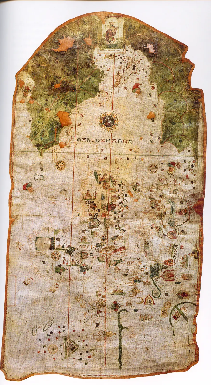
Juan de la Cosa's chart · 1500. It is not a map of the route of Columbus's first voyage. The image reproduces the chart preserved in the Naval Museum, MNM 257.
Cantino planisphere · 1502. The name corresponds to Alberto Cantino, who obtained the map, and does not identify the cartographer. The navigation lines are not itineraries of a specific expedition.
Caverio planisphere · Around 1505. The dating is approximate. It describes accumulated cartographic knowledge; it is not presented as a map carried aboard by Columbus or Ojeda.
Universalior cogniti orbis tabula · 1507–1508. The image preserves geographic hypotheses of the time. Its date is that of the cartography, not of a voyage represented.
Universalis cosmographia · 1507. The consultable reproduction does not imply that the navigators of any expedition used this map. Compare the geographic hypotheses with those of the Carta marina of 1516.
Fragment of the Piri Reis world map · 1513. Only a fragment survives. The place names and coastal outlines require specialized reading; the image is not a complete description of the world.
Carta marina navigatoria · 1516. The images and texts combine nautical information and the author's interpretations. It does not record the voyage of Solís or Magellan.
Americae sive quartae orbis partis nova et exactissima descriptio · 1562. The copy in the image is reproduced from Wikimedia Commons; the institutional record allows comparison with another copy of the same work. It is not a reconstruction of all the routes.
Americae sive novi orbis, nova descriptio · 1570. The depictions of the far south and the interior territories contain incomplete information and hypotheses of the period.
Descriptionis Ptolemaicae augmentum: set of plates · Atlas of 1597; record of a 1964 facsimile; montage of reproductions with no precise date. The linked record describes a 1964 facsimile with an introduction by R. A. Skelton. The image is a montage of plates, not a single historical sheet. To cite a specific region its plate and edition must be located.
Art and memory
- Universal chart of Juan de la Cosa · 1500
- Hurricane during Columbus's second voyage · 1613, German edition
- Portrait of a Man, thought to be Christopher Columbus · Before 1519
Other expeditions with shared protagonists
- Ojeda's Expedition: Gulf of Venezuela
- Columbus's fall as governor
- Ojeda's Second Voyage: Coquibacoa
- Columbus's return and the death of Isabella of Castile
- Ojeda's Expedition to Nueva Andalucía (1509–1510)
Mentioned in other entries
- Diego Velázquez de Cuéllar
- Juan de la Cosa
- Juan Ponce de León
- Sebastián de Ocampo
- Voyage of Ojeda, Juan de la Cosa and Vespucci
- 1499: The race of the discoverers
Una mención permite investigar una relación; no implica participación en la expedición ni acredita por sí sola el pasaje citado.
Sources and references
- [B9] Select Letters of Christopher Columbus. Cristóbal Colón; edición de R. H. Major. Hakluyt Society edition (nineteenth century). Original record
- [B24] Historia de las Indias, volumen 2 de 5. Bartolomé de las Casas. Work written between 1527 and 1561; edition of 1875. Original record
- [B2] History of the Indies. Volume I. Bartolomé de las Casas. 16th-century text; Madrid edition, 1875; digitization, 2007. Original record
- [B1] General and Natural History of the Indies: second part, first volume. Gonzalo Fernández de Oviedo; edition by José Amador de los Ríos. Work of the 16th century; linked volume edited in 1852. Original record
- [B18] Grants and confirmations of encomiendas: documentary guide. Archivo General de Indias. Contemporary guide to colonial documentation. Original record
- [B12] Historia del almirante don Cristóbal Colón. Hernando Colón. Mid-sixteenth-century work; Madrid edition. Original record
- [B14] Colección de los viages y descubrimientos, tomo II: Documentos de Colón y de las primeras poblaciones. Martín Fernández de Navarrete. Edition of 1859. Original record
- [B5] De Orbe Novo, volumen 1. Pedro Mártir de Anglería; traducción de Francis A. MacNutt. Decades written from 1493; translation of 1912. Original record
- [B8] Cristóbal Colón, Diccionario Biográfico Español. Juan Pérez de Tudela y Bueso · Real Academia de la Historia. n.d.; edition date not established. Original record
- [B37] Reivindicación burgalesa de Alonso de Ojeda, famoso conquistador y colonizador del Nuevo Mundo. Gonzalo Miguel Ojeda. Boletín de la Institución Fernán González 122 (1953), pp. 432–449. Original record
- The Columbian voyages: synthesis and documents. Ministry of Culture / State Archives. Institutional synthesis; it distinguishes the four voyages and their dates.
- Evaluation of the historic and archaeological site of La Isabela. ICOMOS / UNESCO, 2021 evaluation, nomination 1628. It distinguishes La Isabela, in the north of the present-day Dominican Republic, from La Navidad, located to the west. It does not turn the regional setting of the fort into an exact archaeological coordinate.
Documents and call numbers
- Reg. Alex. VI, lat. 253, f. 1-3 · Bull Inter Caetera
- PATRONATO,295,N.3 · Instructions to Columbus for the second voyage
General bibliography guides further reading; it is not a pinpoint reference for every claim. Page, chapter and archival references are identified at the relevant passages.
Further reading and comparison
- First Voyage of Columbus: Discovery of America · 1492
- Exploration of southern Cuba and Jamaica · 1494
- Expeditions on Hispaniola and the repartimiento system · 1495
- Return and outcome of Columbus's second voyage · 1496
- Third Voyage of Columbus: Discovery of the Mainland · 1498
- Fourth Voyage of Christopher Columbus · 1502
Examine and compare documents
- The Caribbean: tribute, captivity and resistance — Which voices does a conquest account preserve, and which are mediated? ·
- Columbus’s four voyages: different documents — Did Columbus write every account of the four voyages? ·
Documentary supplements with their own review scope; they do not certify a complete collation of this entry.
Send comments to the author
Found an error or have information to contribute? Write privately to the author.