

Ojeda's Expedition: Gulf of Venezuela
In this entry · 19 sections
- Context
- Stages
- Events of this expedition
- Route data
- Outcome
- Limits of the evidence
- Expedition facts
- Organisation
- Objectives
- Encounters and societies
- Recorded vessels
- People and societies
- Related people
- Related cartography
- Art and memory
- Other expeditions with shared protagonists
- Sources and references
- Further reading and comparison
- Sources of the related expeditions
Expedition · 1499. Alonso de Ojeda.
O’Donnell explains Ojeda’s licence and the restrictions concerning Portugal and territories already visited by Columbus. He describes one caravel initially fitted out at El Puerto de Santa María and dates departure to 18 May 1499, with Vespucci and Juan de la Cosa as chief pilot. [B36]
The study reconstructs the route through Trinidad, Paria, Margarita, Cumaná, Maracapana, Curaçao and Cabo de la Vela. It describes repairs, construction of a brigantine, fighting and the subsequent visit to Hispaniola. This reconstruction is not treated as a route observed with modern coordinates. [B36]
O’Donnell places return to Cádiz in June 1500 with gold, pearls and slaves. He connects La Cosa’s subsequent work with his chart, but interprets the world map as a work expanded with information from other voyages, rather than an exclusive diary of this one. [B36] [B36]
Context
The new exploration licenses opened participation to other shipowners and navigators in areas previously covered by Columbus. The obtaining of metals, pearls and commercial profit was combined with coastal survey. [B36]
Stages
- May 1499, Bay of Cádiz: Preparation and departure for the Atlantic. [B36]
- 1499, Canary Islands: Stopover on the route to America. [B36]
- 1499, Coast of the Mainland (Tierra Firme): Trinidad, the Gulf of Paria, Margarita, Cumaná and Maracapana in O’Donnell’s reconstructed itinerary. [B36]
- 1499, Gulf of Venezuela: O’Donnell describes travel via Curaçao to Cabo de la Vela; the gulf marker represents a regional area, not an exact stop established by that passage. [B36]
- 1499, Cabo de la Vela: Western end of the main route. [B36]
- 1500, Return to the Peninsula: End of the Atlantic campaign. [B36]
Events of this expedition
Route data
- 3 or 4 ships according to the reconstruction.
- Juan de la Cosa used what was covered in his universal chart of 1500.
- The printed letters attributed to Vespucci spread the idea of a “new world”.
Outcome
The campaign broadened cartographic knowledge of the northern South American coast. [B36]
Juan de la Cosa's 1500 chart makes it possible to study the accumulation of information, but it is not a log of this single expedition. [B36]
Limits of the evidence
Reconstructions of Vespucci's movements and the relationships between his texts require cross-checking. [B36]
The traditional explanation of the name Venezuela is not presented as a certainty that resolves the whole toponymic discussion.
Expedition facts
| Date | 1499 |
|---|---|
| Leader | Alonso de Ojeda |
| Departure | Cádiz |
| Destination | — |
| Period | 1499–1500 |
Organisation
The departure is placed on 18 May 1499 in the area of the Bay of Cádiz, from El Puerto de Santa María. The campaign relied on Juan de la Cosa's nautical and cartographic experience. [B36]
Objectives
- To survey the coasts of the mainland (Tierra Firme) [B36]
- To obtain geographic information and marketable resources [B36]
Encounters and societies
O’Donnell describes fighting at Puerto Flechado and a return with gold, pearls and enslaved people. This reconstruction of the voyage and its violence is attributed to the study. [B36]
Recorded vessels
- O’Donnell describes one caravel initially fitted out at El Puerto de Santa María and the seizure of equipment and another caravel on the African coast. This initial composition is not equated with a constant four-ship fleet. [B36]
People and societies
- Alonso de Ojeda: Captain of the expedition [B36]
- Juan de la Cosa: Pilot and cartographer [B36]
- Américo Vespucio: Italian merchant identified by O’Donnell among the participants [B36]
Related people
Related cartography
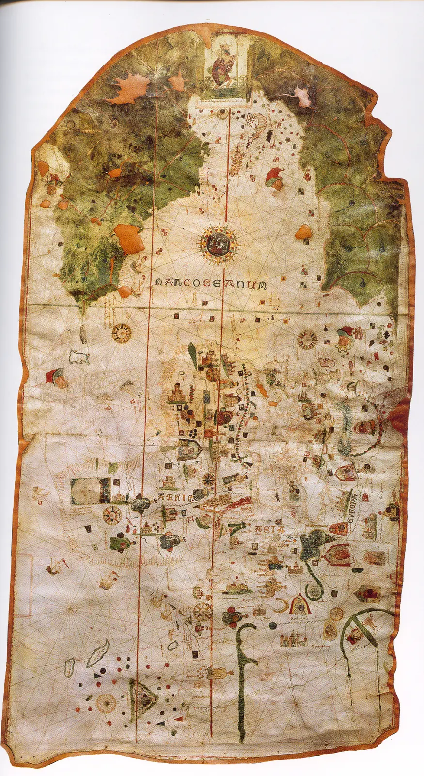
Juan de la Cosa's chart · 1500. It is not a map of the route of Columbus's first voyage. The image reproduces the chart preserved in the Naval Museum, MNM 257.
Cantino planisphere · 1502. The name corresponds to Alberto Cantino, who obtained the map, and does not identify the cartographer. The navigation lines are not itineraries of a specific expedition.
Caverio planisphere · Around 1505. The dating is approximate. It describes accumulated cartographic knowledge; it is not presented as a map carried aboard by Columbus or Ojeda.
Universalior cogniti orbis tabula · 1507–1508. The image preserves geographic hypotheses of the time. Its date is that of the cartography, not of a voyage represented.
Universalis cosmographia · 1507. The consultable reproduction does not imply that the navigators of any expedition used this map. Compare the geographic hypotheses with those of the Carta marina of 1516.
Fragment of the Piri Reis world map · 1513. Only a fragment survives. The place names and coastal outlines require specialized reading; the image is not a complete description of the world.
Carta marina navigatoria · 1516. The images and texts combine nautical information and the author's interpretations. It does not record the voyage of Solís or Magellan.
Americae sive novi orbis, nova descriptio · 1570. The depictions of the far south and the interior territories contain incomplete information and hypotheses of the period.
Art and memory
- Portrait of Américo Vespucio · 1568
- Portrait of Juan de la Cosa · Date not established
- Universal chart of Juan de la Cosa · 1500
Other expeditions with shared protagonists
- Second Voyage of Columbus: Colonization of the Antilles
- Expedition of Rodrigo de Bastidas and Juan de la Cosa
- Juan de la Cosa's Expedition to Urabá
Sources and references
- [B131] Juan de la Cosa: voyages and documentation. University of Valladolid, UVaDOC. n.d.; edition date not established. Original record
- [B69] Juan de la Cosa's chart. Juan de la Cosa. 1500; MNM 257. Original record
- [B1] General and Natural History of the Indies: second part, first volume. Gonzalo Fernández de Oviedo; edition by José Amador de los Ríos. Work of the 16th century; linked volume edited in 1852. Original record
- [B20] Colección de los viages y descubrimientos que hicieron por mar los españoles desde fines del siglo XV, tomo III. Martín Fernández de Navarrete. Madrid, Imprenta Real, 1829. Original record
- [B173] The Letters of Amerigo Vespucci, and Other Documents Illustrative of His Career. Américo Vespucio, Cristóbal Colón y Bartolomé de las Casas; edición de Clements R. Markham. Hakluyt Society edition (1894). Original record
- [B5] De Orbe Novo, volumen 1. Pedro Mártir de Anglería; traducción de Francis A. MacNutt. Decades written from 1493; translation of 1912. Original record
- [B36] Juan de la Cosa, Diccionario Biográfico Español. Real Academia de la Historia. n.d.; edition date not established. Original record
- Juan de la Cosa: voyages and documentation. University of Valladolid, UVaDOC. Study of the Atlantic voyages; it compares sources and reconstructions of itineraries.
Documents and call numbers
- INDIFERENTE,415,L.1 · Capitulation with Ojeda
- Fondo Mediceo · Vespucci's letter to Lorenzo di Pierfrancesco de' Medici
General bibliography guides further reading; it is not a pinpoint reference for every claim. Page, chapter and archival references are identified at the relevant passages.
Further reading and comparison
- Voyage of Pedro Alonso Niño and Cristóbal Guerra · 1499
- Pinzón's Expedition: Discovery of Brazil and the Amazon · 1499
- Ojeda's Second Voyage: Coquibacoa · 1502
- Ojeda's Expedition to Nueva Andalucía (1509–1510) · 1509
Send comments to the author
Found an error or have information to contribute? Write privately to the author.