

Granata Nova et California
In this entry · 8 sections
1597 · Cornelis van Wytfliet · Bibliothèque nationale de France (Gallica)
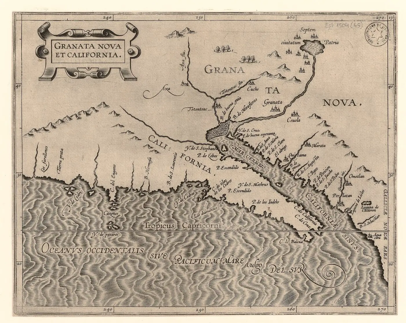
Regional plate of Wytfliet's atlas with the Gulf of California, Nueva Galicia and the Pacific coast of New Spain, as known after the voyages of Cabrillo and Vizcaíno.
How to interpret the map
It represents California as a peninsula, with unreliable names and distances for the northern coast. Copy from the Bibliothèque nationale de France; it is not the plate of the 1964 facsimile in the other Wytfliet record.
Provenance and rights
Cornelis van Wytfliet, Descriptionis Ptolemaicae augmentum, Louvain, 1597. Bibliothèque nationale de France; reproduction via Wikimedia Commons.
Institutional record · Public domain
Related expeditions
Related protagonists
Maps
- Tenochtitlan and the Gulf of Mexico
- Americae sive quartae orbis partis nova et exactissima descriptio
- Americae sive novi orbis, nova descriptio
- Painting of Teozacoalco and documentation of its geographic report
- Descriptionis Ptolemaicae augmentum: set of plates
- Hispaniae Novae sive Magnae, recens et vera descriptio
Art
- Portrait of Hernán Cortés
- Portrait of Malintzin o doña Marina
- Plan of Tenochtitlan from the second Letter of Relation
- Azcatitlan Codex: arrival of Cortés and the Spaniards
- Huexotzinco Codex
- Lienzo de Tlaxcala
- Massacre of Cholula, from the Lienzo de Tlaxcala
- Mexico and Cusco, in Civitates Orbis Terrarum
Show all links (24)
- Aubin Codex: arrival of Cortés
- Florentine Codex, Book XII: the conquest of Mexico
- History of the Indies of New Spain: Cortés and Malintzin
- Glasgow Manuscript: Description of Tlaxcala
- Description of the West Indies and title pages of the Décadas
- Cortés's entry into Tabasco
- Arrival of Cortés at Veracruz
- Meeting of Cortés and Moctezuma
- Death of Moctezuma
- The Noche Triste (Sad Night)
- Battle of Otumba
- Capture of Tenochtitlan
- Capture of Cuauhtémoc
- Conquest of Mexico: series of 24 enconchados
- The Interview of Cortes and Motezuma
- Hernán Cortés and Moctezuma's Ambassadors. April 1519
Related milestones
- Villa Rica de la Vera Cruz
- Alliance with the lords of Tlaxcala
- Cortés and Moctezuma meet in Tenochtitlan
- Smallpox epidemic in central Mexico
- Retreat from Tenochtitlan: the Noche Triste
- The fall of Tenochtitlan
- Oñate takes possession of New Mexico
Sources of the related expeditions
- [B10] True History of the Conquest of New Spain
- [B11] Cronología General Iberoamericana: siglo XVI
- [B13] Relatos de viaje del siglo XVI
- [B15] La Era de la Exploración: navegantes y conquistadores del siglo XVI
- [B22] Memoirs of the Conquistador Bernal Diaz del Castillo, volumen 1
- [B61] Lienzo de Tlaxcala
- [B70] Florentine Codex: digital edition
- [B77] Crónica de la Nueva España
Show all links (24)
- [B78] The alliances and military forces before the siege of México-Tenochtitlan
- [B79] From Cozumel to Cempoala: cross-checked chronology of 1519
- [B81] Hernán Cortés portal: works and documents
- [B84] Alliance and conflict with the totonaque
- [B86] The Pleasant Historie of the Conquest of the Weast India, now called New Spayne
- [B89] History of the Indians of New Spain
- [B90] The Mexica and their alliance policy during the conquest
- [B92] History of the Conquest of Mexico, volumen 1
- [B93] Cronología de Hernán Cortés
- [B94] Hernán Cortés, Diccionario Biográfico Español
- [B95] Florentine Codex, Book 12: transcriptions and translations
- [B154] Archaeology and Legend: historical memory of Acoma
- [B198] Juan de Oñate Salazar
- [B209] In the Land of Frozen Fires: A History of Occupation in El Malpais Country
- [B218] Acoma Pueblo: Ancient City in the Sky
- [B219] Camino Real in New Mexico, AD 1598–1881: National Register documentation
Send comments to the author
Found an error or have information to contribute? Write privately to the author.