

Plan of Tenochtitlan from the second Letter of Relation
In this entry · 8 sections
1524 · Anonymous engraver; design based on European and Indigenous sources; published by Friedrich Peypus · Library of Congress; Newberry Library and other collections
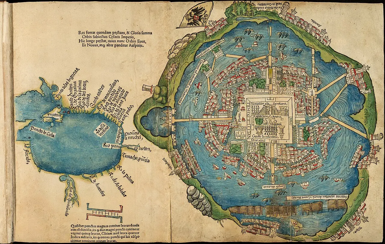
First printed European image of Tenochtitlan: main temple, plaza, causeways, lakes and canoes. It translates Indigenous information into a format intelligible to the European public. The direct attribution to Cortés is no longer simply accepted. It was accompanied by a map of the gulf.
Work identification
- Folded woodcut
- Library of Congress; Newberry Library and other collections
- Muy alta para la fecha; alta para el origen del diseño
Credits and image provenance
Unidentified engraver; published with Hernán Cortés's account. Newberry Library / reproduction on Wikimedia Commons. Provenance of the reproduction indicated in its link.
Reproduction record · Public domain

Related expeditions
- Conquest of Mexico: fall of the Aztec Empire
- Córdoba's Expedition: Discovery of Yucatán
- Grijalva's Expedition: Contact with the Aztec Empire
Related protagonists
- Francisco Hernández de Córdoba
- Juan de Grijalva
- Antón de Alaminos
- Bernal Díaz del Castillo
- Francisco de Montejo
- Jerónimo de Aguilar
- Juan Díaz
- Malintzin o doña Marina
Show all links (10)
Maps
- Tenochtitlan and the Gulf of Mexico
- Americae sive quartae orbis partis nova et exactissima descriptio
- Americae sive novi orbis, nova descriptio
- Painting of Teozacoalco and documentation of its geographic report
- Descriptionis Ptolemaicae augmentum: set of plates
- Granata Nova et California
- Hispaniae Novae sive Magnae, recens et vera descriptio
Art
- Portrait of Hernán Cortés
- Portrait of Juan de Grijalva
- Portrait of Malintzin o doña Marina
- Portrait of Pedro de Alvarado
- Azcatitlan Codex: arrival of Cortés and the Spaniards
- Huexotzinco Codex
- Lienzo de Tlaxcala
- Massacre of Cholula, from the Lienzo de Tlaxcala
Show all links (25)
- Mexico and Cusco, in Civitates Orbis Terrarum
- Aubin Codex: arrival of Cortés
- Florentine Codex, Book XII: the conquest of Mexico
- History of the Indies of New Spain: Cortés and Malintzin
- Glasgow Manuscript: Description of Tlaxcala
- Description of the West Indies and title pages of the Décadas
- Cortés's entry into Tabasco
- Arrival of Cortés at Veracruz
- Meeting of Cortés and Moctezuma
- Death of Moctezuma
- The Noche Triste (Sad Night)
- Battle of Otumba
- Capture of Tenochtitlan
- Capture of Cuauhtémoc
- Conquest of Mexico: series of 24 enconchados
- The Interview of Cortes and Motezuma
- Hernán Cortés and Moctezuma's Ambassadors. April 1519
Related milestones
- Hernández de Córdoba reaches Yucatán
- Juan de Grijalva’s reconnaissance
- Juan de Grijalva reaches San Juan de Ulúa
- Villa Rica de la Vera Cruz
- Alliance with the lords of Tlaxcala
- Cortés and Moctezuma meet in Tenochtitlan
- Smallpox epidemic in central Mexico
- Retreat from Tenochtitlan: the Noche Triste
Show all links (9)
Sources of the related expeditions
- [B1] General and Natural History of the Indies: second part, first volume
- [B10] True History of the Conquest of New Spain
- [B11] Cronología General Iberoamericana: siglo XVI
- [B13] Relatos de viaje del siglo XVI
- [B15] La Era de la Exploración: navegantes y conquistadores del siglo XVI
- [B19] The Yucatán–Honduras coast, scene of contact 500 years ago (Francisco Hernández de Córdoba, 1517)
- [B22] Memoirs of the Conquistador Bernal Diaz del Castillo, volumen 1
- [B56] Préstamos latentes entre el maya y el español en cuatro textos del siglo XVI en Yucatán
Show all links (26)
- [B61] Lienzo de Tlaxcala
- [B70] Florentine Codex: digital edition
- [B77] Crónica de la Nueva España
- [B78] The alliances and military forces before the siege of México-Tenochtitlan
- [B79] From Cozumel to Cempoala: cross-checked chronology of 1519
- [B81] Hernán Cortés portal: works and documents
- [B84] Alliance and conflict with the totonaque
- [B86] The Pleasant Historie of the Conquest of the Weast India, now called New Spayne
- [B89] History of the Indians of New Spain
- [B90] The Mexica and their alliance policy during the conquest
- [B92] History of the Conquest of Mexico, volumen 1
- [B93] Cronología de Hernán Cortés
- [B94] Hernán Cortés, Diccionario Biográfico Español
- [B95] Florentine Codex, Book 12: transcriptions and translations
- [B103] General History of the Indies
- [B106] Juan de Grijalba
- [B142] Francisco Hernández de Córdoba
- [B145] Bernal Díaz describes the expedition of Francisco Hernández de Córdoba
Send comments to the author
Found an error or have information to contribute? Write privately to the author.