

Universal chart of Diego Ribero: reproduction
In this entry · 8 sections
Model of 1529; 2019 reproduction based on a 19th-century facsimile · Diego Ribero; reproduction cataloged by the IGN · National Geographic Institute, Map library
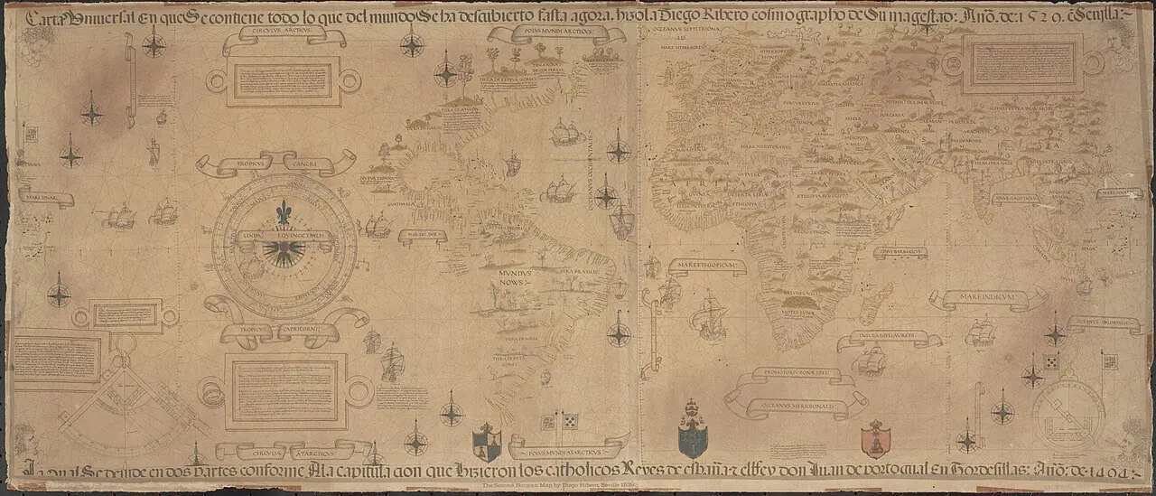
Reference for studying the representation of the world after the first circumnavigation and the demarcation disputes.
How to interpret the map
The linked copy is a 2019 reproduction, not the original of 1529. The chain of reproduction is expressly kept.
Provenance and rights
Diego Ribero; facsimile by William Griggs, around 1887, of the copy in the Palazzo di Propaganda Fide. National Library of Australia / Wikimedia Commons.
Institutional record · Public domain

Related expeditions
- First Circumnavigation: The Magellan–Elcano Expedition
- Loaísa's Expedition: Second Attempt on the Moluccas
- Saavedra's Expedition: Relief of the Moluccas
- García de Lerma's Expedition to Santa Marta
- Jerónimo Dortal's Expedition to Paria
- Fleet of Jorge de Espira and Nicolás Federmann
- Expedition of the Fernández de Lugo to Santa Marta
- Diego de Sanabria's Expedition
- Domingo de Vera's Expedition to Guiana
- Joint Expedition of Solís and Vicente Yáñez Pinzón
- Pedrarias's Fleet to Castilla del Oro
- Expedition of Gil González Dávila and Andrés Niño
- Las Casas's Settlement Expedition to Cumaná
- Esteban Gómez's Expedition to North America
- Sebastian Cabot's Expedition to the Río de la Plata
- Diego García de Moguer's Expedition
- Francisco de Montejo's First Expedition to Yucatán
- Pánfilo de Narváez's Expedition to Florida
- Pizarro's Expedition from Spain for the Conquest of Peru
- Diego de Ordás's Expedition to the Orinoco
- Pedro de Heredia's Expedition to Cartagena
- Hernando de Soto's Expedition to Florida
- Cabeza de Vaca's Expedition to the Río de la Plata
- Expedition of Mencía Calderón and Juan de Salazar
- Jaime Rasquín's Expedition to the Río de la Plata
- Pedro Menéndez de Avilés's Expedition to Florida
- Pedro Maraver de Silva's Expedition to Nueva Extremadura
- Diego Fernández de Serpa's Expedition to Nueva Andalucía
- Juan Ortiz de Zárate's Expedition to the Río de la Plata
- Fleet of Diego Columbus, Governor of the Indies
Related protagonists
- Alonso Luis Fernández de Lugo
- Álvar Núñez Cabeza de Vaca
- Andrés Niño
- Bartolomé de las Casas
- Diego Colón
- Diego de Ordás
- Diego de Sanabria
- Diego Fernández de Serpa
Show all links (48)
- Diego García de Moguer
- Domingo de Vera e Ibargoyen
- Esteban Gómez
- Fernando de Magallanes
- Francisco de Montejo
- Francisco Pizarro
- García de Lerma
- García Jofre de Loaísa
- Gil González Dávila
- Gonzalo Gómez de Espinosa
- Hernando de Soto
- Jaime Rasquín
- Jerónimo Dortal
- Jorge de Espira
- Juan de Salazar
- Juan Díaz de Solís
- Juan Ortiz de Zárate
- Juan Sebastián Elcano
- Mencía Calderón
- Nicolás Federmann
- Pánfilo de Narváez
- Pedro Arias Dávila (Pedrarias)
- Pedro de Heredia
- Pedro Fernández de Lugo
- Pedro Maraver de Silva
- Pedro Menéndez de Avilés
- Sebastián Caboto
- Vicente Yáñez Pinzón
- Alonso de Salazar
- Álvaro de Saavedra Cerón
- Andrés de Urdaneta
- Antonio Pigafetta
- Felipe de Hutten
- Gaspar de Espinosa
- Hernando de la Torre
- Juan Gómez de Espinosa
- Luis de Cárdenas
- Pedro de Fuentes
- Pedro de Solís Barrasa
- Pedro Gómez
Maps
- Miller Atlas: world map
- Nautical planisphere of Lopo Homem
- Universale descrittione di tutta la terra conosciuta fin qui
- Nova et aucta orbis terrae descriptio
- Africae tabula nova
- Asiae nova descriptio
- Maris Pacifici
- Vera totius expeditionis nauticae: voyages of Drake and Cavendish
Show all links (11)
Art
- Portrait of Álvar Núñez Cabeza de Vaca
- Portrait of Andrés de Urdaneta
- Portrait of Bartolomé de las Casas
- Portrait of Diego Colón
- Portrait of Diego de Ordás
- Portrait of Felipe de Hutten
- Portrait of Francisco Pizarro
- Portrait of Gil González Dávila
Show all links (25)
- Portrait of Hernando de Soto
- Portrait of Juan de Salazar
- Portrait of Pánfilo de Narváez
- Portrait of Pedro de Heredia
- Portrait of Pedro Menéndez de Avilés
- Portrait of Sebastián Caboto
- Coat of arms of Gonzalo Gómez de Espinosa
- La Descrittione di tutto il Peru
- Americae sive quartae orbis partis nova et exactissima descriptio
- Americae pars sexta: Pizarro and the conquest of Peru
- Imprisonment of Diego de Almagro (Jacobus Almagrus… in carcere)
- Pizarro, Almagro and Luque form a partnership in Panama
- Description of the West Indies and title pages of the Décadas
- Illustrations of Martín de Murúa's histories
- New Chronicle and Good Government: Pizarro and Atahualpa at Cajamarca
- Portrait of Ferdinand Magellan
- Imaginary portrait of Juan Sebastián Elcano
Related milestones
- Foundation of Panama City
- Magellan begins the first circumnavigation
- Encounters in Patagonia during the winter stay
- Mutiny at San Julián
- Magellan finds the strait
- Magellan’s fleet reaches Guam
- The expedition lands at Homonhon
- Magellan and Rajah Humabon at Cebu
Show all links (28)
- Battle of Mactan and death of Magellan
- The Trinidad attempts an eastward Pacific return
- Elcano completes the first circumnavigation
- Encounters with the polities of Nicoya and Nicaragua
- Esteban Gómez surveys the North American coast
- Departure of Loaísa’s fleet
- Toribio Alonso de Salazar sights Bokak
- Construction of Sancti Spiritus fort
- Statements by survivors of the Trinidad
- Treaty of Zaragoza
- Capitulation of Toledo with Pizarro
- Foundation of San Miguel, predecessor of Piura
- Spanish foundation of Cartagena de Indias
- Pizarro’s forces enter Cusco
- Definitive establishment of San Francisco de Quito
- Foundation of the City of the Kings, Lima
- End of Cabeza de Vaca and his companions’ journey
- Manco Inca’s revolt and the siege of Cusco
- De Soto’s expedition reaches the Mississippi
- Menéndez de Avilés founds San Agustín
Sources of the related expeditions
- [B3] The Spanish Lake
- [B4] España y el Pacífico: un breve repaso a las expediciones españolas de los siglos XVI al XVIII
- [B6] Spanish discoveries in the South Sea
- [B7] Los hallazgos españoles en el Pacífico
- [B11] Cronología General Iberoamericana: siglo XVI
- [B13] Relatos de viaje del siglo XVI
- [B15] La Era de la Exploración: navegantes y conquistadores del siglo XVI
- [B16] Historia de las Indias, volumen 3 de 5
Show all links (102)
- [B17] Francisco Pizarro González, Diccionario Biográfico Español
- [B20] Colección de los viages y descubrimientos que hicieron por mar los españoles desde fines del siglo XV, tomo III
- [B21] Documentation of Magellan's fleet
- [B23] The First Voyage Round the World, by Magellan
- [B25] Portuguese Cartography in the Renaissance
- [B26] The Discovery and Conquest of the Molucco and Philippine Islands
- [B27] History of the Philippine Islands
- [B28] Colección de los viages y descubrimientos: Expediciones al Maluco. Viage de Magallanes y de Elcano
- [B30] First Voyage Around the World
- [B32] Caminos sobre la mar. Las expediciones a las islas de la especiería después de Magallanes, 1525–1564
- [B33] Historia de las Indias, volumen 4 de 5
- [B35] First Voyage Around the World: critical edition
- [B38] La Relación del primer viaje alrededor del mundo de Antonio Pigafetta y sus traducciones al español
- [B39] Reconstruction of the Trinidad’s route: the Navy’s KMZ file
- [B40] Primer viaje alrededor del mundo: edición de Leoncio Cabrero
- [B41] Punzorol’s letter from Tidore: critical edition and Spanish translation
- [B42] Gonzalo Gómez de Espinosa’s letter to Charles I about the Trinidad
- [B43] Vicente Yáñez Pinzón, Diccionario Biográfico Español
- [B44] Elcano’s letter to the emperor (1522): copy and AGI transcription
- [B45] Pedro Gómez: servant aboard the Trinidad
- [B46] The crews of the first circumnavigation
- [B47] Virtual navigation of Gonzalo Gómez de Espinosa: attempted eastward return in 1522
- [B48] Gonzalo Gómez de Espinosa, Diccionario Biográfico Español
- [B49] Historia general y natural de las Indias, tomo II: primera parte de la segunda parte
- [B51] La gran isla de Nueva Guinea: descubrimiento y navegación por los españoles (1528–1607)
- [B55] Colección de los viages y descubrimientos: Expediciones al Maluco. Viages de Loaisa y de Saavedra
- [B57] Álvaro Saavedra Cerón
- [B59] The descendants of licenciado Gaspar de Espinosa
- [B60] Origins of the San Juan governorship: Gaspar de Espinosa
- [B62] Nautical treatises and documents of Magellan and Elcano
- [B111] Shipwrecks and account of the journey to Florida
- [B113] Juan Sebastián Elcano, Diccionario Biográfico Español
- [B114] García Jofre de Loaysa
- [B119] García Jofre de Loaísa's expedition, 1525–1526
- [B125] A legal and historical study of Loaísa’s expedition and the sale of rights over the Moluccas
- [B129] Juan Díaz de Solís, Diccionario Biográfico Español
- [B133] El conquistador Nicolás de Ribera el Viejo y la fundación del hospital de naturales de Ica, 1522–1563
- [B143] Pedro Arias Dávila
- [B151] El mito de El Dorado: móvil de exploración y conquista en Sudamérica (siglo XVI)
- [B157] Account of the voyage of Captain Álvaro de Saavedra Cerón to the Moluccas
- [B159] A Narrative of the Expedition of Hernando de Soto into Florida
- [B160] Florida: Fort Caroline National Memorial
- [B169] Pedrarias's fleet for Castilla del Oro, 1514
- [B170] La hueste indiana en los protocolos notariales de Sevilla: las primeras expediciones al Río de la Plata (1534 a 1552)
- [B176] Pedro Fernández de Lugo
- [B179] Jorge Hohermuth
- [B188] Jorge de Espira's fleet: preparations and departure of 1534
- [B193] Gil González Dávila
- [B194] Pedro de Heredia
- [B196] Andrés Niño
- [B197] Pánfilo de Narváez
- [B200] Hernando de Soto
- [B201] Sebastián Caboto
- [B206] El nacimiento de un sistema
- [B210] Pedro Menéndez de Avilés y Alonso de la Campa, Diccionario Biográfico Español
- [B211] Objectives of Cabot's expedition
- [B212] Navigation and the search for the passage to the South Sea
- [B213] Pedro de Heredia and Cartagena
- [B214] History of Santa Marta and the New Kingdom of Granada
- [B216] Memoir of the happy result and prosperous voyage of the fleet commanded by the illustrious Captain-General Pedro Menendez de Aviles
- [B217] Account of Pánfilo de Narváez's voyage (1527)
- [B221] Account of Hernando de Soto's expedition
- [B222] Los trabajos del navegante Andrés Niño en el descubrimiento y exploración de las Indias
- [B225] St. Augustine, Florida’s Colonial Capital
- [B230] Esteban Gómez, piloto de la Casa de la Contratación de las Indias
- [B232] Francisco de Montejo
- [B234] Juan Ortiz de Zárate
- [B236] Diego de Ordás
- [B238] Mencía Calderón de Sanabria
- [B242] Guayana, provincia de
- [B257] El burgalés Don Juan de Garay
- [B261] Los Comentarios de Álvar Núñez Cabeza de Vaca
- [B262] Gómez, Esteban: pilot and explorer
- [B263] New Spain and the reconfiguration of the territory
- [B264] Diego de Ordás
- [B266] Ships and settlers of Domingo de Vera for the El Dorado venture
- [B268] Preparation of Juan Ortiz de Zárate's expedition
- [B269] Explorations of the Río de la Plata
- [B271] Political and legal power in Yucatán in the first half of the sixteenth century
- [B274] Bartolomé de las Casas
- [B275] Diego Colón Moñiz
- [B277] Diego Fernández de Serpa
- [B278] Diego García de Moguer
- [B280] García de Lerma
- [B281] Jerónimo de Ortal
- [B282] Diego de Sanabria
- [B290] Armada española desde la unión de los reinos de Castilla y de León, tomo II
- [B298] Rasquín, Jaime: registro de autoridad
- [B300] Results and consequences of the first circumnavigation
- [B301] Un muy breve relato de una vida muy larga: Bartolomé de Las Casas (1484–1566)
- [B302] Los vascos en la expedición de García de Lerma a Santa Marta
- [B303] Account of Jaime Rasquín's voyage, 1559: Add MS 17607
- [B304] Fernández de Serpa, Diego
- [B306] Desaparecido de camino a Nueva España. El viaje de Juan Vespucci de 1527
Send comments to the author
Found an error or have information to contribute? Write privately to the author.