

Maris Pacifici
In this entry · 8 sections
1589 · Abraham Ortelius · State Library of New South Wales; reproduction of the work on Wikimedia Commons
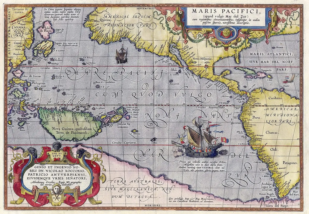
Map devoted to the Pacific showing America, Asia, New Guinea and a large hypothetical southern land.
How to interpret the map
The ship Victoria recalls the circumnavigation, but does not make the map a layout of the route of 1519–1522. The date of the map must be distinguished from that of the voyage.
Provenance and rights
Abraham Ortelius. State Library of New South Wales; reproduction of the work on Wikimedia Commons. Provenance of the reproduction indicated in its link.
Institutional record · Public domain

Related expeditions
- First Circumnavigation: The Magellan–Elcano Expedition
- Loaísa's Expedition: Second Attempt on the Moluccas
- Saavedra's Expedition: Relief of the Moluccas
- Mendaña's First Expedition: Discovery of the Solomon Islands
- Mendaña's Second Expedition: Marquesas and Santa Cruz
- Conquest of the Philippines
- Urdaneta's discovery of the return route (tornaviaje)
Related protagonists
- Álvaro de Mendaña
- Andrés de Urdaneta
- Fernando de Magallanes
- García Jofre de Loaísa
- Gonzalo Gómez de Espinosa
- Isabel Barreto
- Juan Sebastián Elcano
- Miguel López de Legazpi
Show all links (24)
- Alonso de Salazar
- Álvaro de Saavedra Cerón
- Antonio Pigafetta
- Felipe de Salcedo
- Guido de Lavezaris
- Hernán Gallego
- Hernando de la Torre
- Juan Gómez de Espinosa
- Luis de Cárdenas
- Pedro de Fuentes
- Pedro de Ortega Valencia
- Pedro Fernández de Quirós
- Pedro Gómez
- Pedro Merino Manrique
- Pedro Sarmiento de Gamboa
- Rodrigo de Espinosa (piloto)
Maps
- Miller Atlas: world map
- Universal chart of Diego Ribero: reproduction
- Nautical planisphere of Lopo Homem
- Universale descrittione di tutta la terra conosciuta fin qui
- Nova et aucta orbis terrae descriptio
- Africae tabula nova
- Asiae nova descriptio
- Vera totius expeditionis nauticae: voyages of Drake and Cavendish
Show all links (10)
Art
- Portrait of Álvaro de Mendaña
- Portrait of Andrés de Urdaneta
- Portrait of Guido de Lavezaris
- Portrait of Pedro Fernández de Quirós
- Coat of arms of Gonzalo Gómez de Espinosa
- Americae sive quartae orbis partis nova et exactissima descriptio
- Description of the West Indies and title pages of the Décadas
- Portrait of Ferdinand Magellan
Show all links (9)
Related milestones
- Magellan begins the first circumnavigation
- Encounters in Patagonia during the winter stay
- Mutiny at San Julián
- Magellan finds the strait
- Magellan’s fleet reaches Guam
- The expedition lands at Homonhon
- Magellan and Rajah Humabon at Cebu
- Battle of Mactan and death of Magellan
Show all links (20)
- The Trinidad attempts an eastward Pacific return
- Elcano completes the first circumnavigation
- Departure of Loaísa’s fleet
- Toribio Alonso de Salazar sights Bokak
- Statements by survivors of the Trinidad
- Treaty of Zaragoza
- Spanish settlement at Cebu
- Urdaneta completes the tornaviaje
- Mendaña reaches Santa Isabel in the Solomons
- Spanish foundation of Manila
- Mendaña reaches the Marquesas Islands
- Attempted colony at Santa Cruz, Nendo
Sources of the related expeditions
- [B3] The Spanish Lake
- [B4] España y el Pacífico: un breve repaso a las expediciones españolas de los siglos XVI al XVIII
- [B6] Spanish discoveries in the South Sea
- [B7] Los hallazgos españoles en el Pacífico
- [B13] Relatos de viaje del siglo XVI
- [B21] Documentation of Magellan's fleet
- [B23] The First Voyage Round the World, by Magellan
- [B25] Portuguese Cartography in the Renaissance
Show all links (58)
- [B26] The Discovery and Conquest of the Molucco and Philippine Islands
- [B27] History of the Philippine Islands
- [B28] Colección de los viages y descubrimientos: Expediciones al Maluco. Viage de Magallanes y de Elcano
- [B30] First Voyage Around the World
- [B32] Caminos sobre la mar. Las expediciones a las islas de la especiería después de Magallanes, 1525–1564
- [B35] First Voyage Around the World: critical edition
- [B38] La Relación del primer viaje alrededor del mundo de Antonio Pigafetta y sus traducciones al español
- [B39] Reconstruction of the Trinidad’s route: the Navy’s KMZ file
- [B40] Primer viaje alrededor del mundo: edición de Leoncio Cabrero
- [B41] Punzorol’s letter from Tidore: critical edition and Spanish translation
- [B42] Gonzalo Gómez de Espinosa’s letter to Charles I about the Trinidad
- [B44] Elcano’s letter to the emperor (1522): copy and AGI transcription
- [B45] Pedro Gómez: servant aboard the Trinidad
- [B46] The crews of the first circumnavigation
- [B47] Virtual navigation of Gonzalo Gómez de Espinosa: attempted eastward return in 1522
- [B48] Gonzalo Gómez de Espinosa, Diccionario Biográfico Español
- [B49] Historia general y natural de las Indias, tomo II: primera parte de la segunda parte
- [B51] La gran isla de Nueva Guinea: descubrimiento y navegación por los españoles (1528–1607)
- [B52] Miguel López de Legazpi
- [B53] The practical conditions of Mendaña’s and Quirós’s voyages to Oceania
- [B54] Events in the Philippine Islands
- [B55] Colección de los viages y descubrimientos: Expediciones al Maluco. Viages de Loaisa y de Saavedra
- [B57] Álvaro Saavedra Cerón
- [B58] Legazpi and Urdaneta: organization of the expedition and tornaviaje
- [B62] Nautical treatises and documents of Magellan and Elcano
- [B68] Documents of Mendaña's expeditions and will of 1595
- [B72] Álvaro de Mendaña y Neira, Diccionario Biográfico Español
- [B83] Christian Doctrine in Spanish and Tagalog
- [B100] The expedition of Legazpi and Urdaneta: the tornaviaje
- [B101] Andrés de Urdaneta virtual voyage: sailing journals of 1565
- [B105] Andrés de Urdaneta y Ceraín, Diccionario Biográfico Español
- [B108] El galeón del diablo: la desventura del San Jerónimo en aguas del océano Pacífico (1566)
- [B113] Juan Sebastián Elcano, Diccionario Biográfico Español
- [B114] García Jofre de Loaysa
- [B115] Guido de Lavezaris
- [B119] García Jofre de Loaísa's expedition, 1525–1526
- [B124] Virtual navigation of Alonso de Arellano: the 1564–1565 fleet
- [B125] A legal and historical study of Loaísa’s expedition and the sale of rights over the Moluccas
- [B126] Sailing accounts and reports by the pilots of Legazpi’s fleet
- [B127] The Voyages of Pedro Fernandez de Quiros, 1595 to 1606, volumen 1
- [B128] Collection of unpublished overseas documents, second series, volume II: The Philippine Islands, I
- [B144] Isabel Barreto, admiral of the Spanish fleet, between fiction and reality
- [B149] Spanish women overseas in history and literature
- [B150] Terra Australis Incognita; Or, A New Southern Discovery
- [B152] Spain and the New World: December anniversaries
- [B155] Mendaña and the Bay of the Star: return of 1568–1569
- [B157] Account of the voyage of Captain Álvaro de Saavedra Cerón to the Moluccas
- [B158] Solomon Islands: campaign of 1567–1569
- [B165] The Philippines: Legazpi (1564–65)
- [B172] Andrés Urdaneta y el Tornaviaje
Send comments to the author
Found an error or have information to contribute? Write privately to the author.